9. November – Stolpersteine vor der Haustür: die Familie Goldbrenner

img_7261
Die Stolpersteine für Lea (1888-1942) und Josef (1890-1942)  Goldbrenner. Foto: Robin Oomkes

Heute ist 9. November – ein Tag der in Berlin vor Allem mit dem Mauerfall verbunden ist. Und das ist gut so – auch wenn es an diesem deutschen Schicksalstag noch vieles anderes zu gedenken gibt. Neben der Hinrichtung Robert Blums am 9.11.1848, der Abdankung des Kaisers am 9.11.1918 und dem Hitlerputsch am 9.11.1923, ist das vor Allem die Reichspogromnacht am 9.11.1938. In dieser Nacht (und an der Nacht des 10.11) überfielen die Nazihorden und ihre Mitläufer Jüdische Geschäfte, Synagogen und andere Eigentümer. Die Aktionen trieben etwa 400 Juden in den Tod; viele mehr wurden verhaftet und in Konzentrationslager überführt.

Zum Gedenken der Reichspogromnacht 1938 finden an vielen deutschen Orten von Freiwilligen veranstaltete Putzaktionen für Stolpersteine statt – jene kleine im Bürgersteig eingelassenen Gedenktafeln aus Messing, die seit 1992 vom Künstler Gunter Demnig überall in Europa  vor den letzten frei gewählten Wohnungen ermordeter Juden angebracht werden.

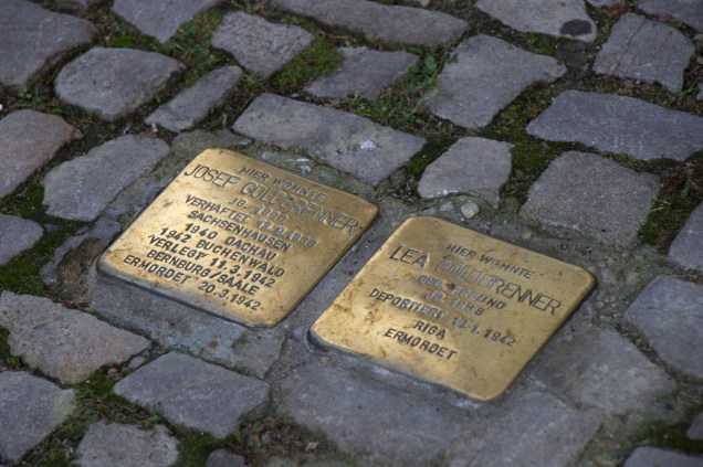
Das Haus Invalidenstrasse 2, Berlin-Mitte. Vor der Haustür befinden sich die zwei Josef und Lea Goldbrenner gedenkenden Stolpersteine. Foto: Robin Oomkes

Vor unserem Wohnhaus in Berlin-Mitte befinden sich zwei Stolpersteine, für Josef und Lea Goldbrenner. Die Steine gab es schon als wir Anfang 2014 einzogen, und uns war von der Familie Goldbrenner nicht mehr bekannt, als was wir auf die Steine lesen konnten: Josef wurde 1890 geboren, 1939 verhaftet und nach dem KZ Sachsenhausen gebracht, und wurde dann 1942 nach verschiedenen Verlegungen (über Dachau und Buchenwald) in der Tötungsanstalt in Bernburg/Saale ermordet. Lea Goldbrenner wurde 1888 geboren und 1942 nach Riga deportiert, wo sie ermordet wurde.

img_8257
Günter und Gisela Wongel putzen die Stolpersteine der Fam. Goldbrenner. Foto: Robin Oomkes

Aber im Juni 2016 erfuhren wir mehr: vor unserer Haustür traf ich zwei knieende Personen, die die Stolpersteine putzten. Es waren Günter Wongel (geb. 1941) und seine Frau Gisela. Sie waren, zusammen mit den Enkelkindern der Familie Goldbrenner 2013 für die Initiative zuständig, Stolpersteine für Josef und Lea Goldbrenner anbringen zu lassen. Günter Wongel ist im Haus Invalidenstr. 2 aufgewachsen; er wohnte mit seinen Eltern in der Wohnung am 5. Stock. (Durch Kriegsschäden gibt es diese Wohnung nicht mehr; das Haus ist heute oben des 4. Stockwerks mit einem flachen Satteldach ausgestattet.)

Günter war zu jung um die Deportation 1942 Lea Goldbrenners bewusst zu erfahren, und zur Zeit der Verhaftung Josef Goldbrenners 1939 war er noch nicht geboren. Trotzdem hat seine Mutter Emilie, die im Haus die Hauswartsstelle inne hatte, ihm viel über die Familie Goldbrenner, die im 1. Stock wohnten, erzählt – wie Lea geweint hat, als Josef von der Gestapo weggeführt wurde, und wie sie damals für die Goldbrenners am Sabbat Feuer gemacht hat. Als es Juden schon nicht mehr erlaubt war, einkaufen zu gehen, hielf Emilie Wongel die Nachbarin indem sie für sie einkaufen ging. Emilie Wongel wurde beschimpft dass sie ‘wohl wieder für die Juden einkäufe’, weil die von ihr gekauften Waren, zum Beispiel frische Gurken, für die Familie Wongel wohl zu teuer waren.

screen-shot-2016-11-09-at-14-26-25
Günter Wongel, Blick auf das Gemeindehaus der Elisabethkirche, Öl auf Pappe1976.

In den siebziger Jahren haben Günter und Gisela Wongel selber noch einige Zeit in der Invalidenstrasse 2 gewohnt, und immer wieder an den weggeführten Nachbarn gedacht. Seitdem sind die beiden nach Pankow umgezogen, aber ein Kunstwerk von der Hand von Günter, gelerntem Grafiker, erinnert noch an die Zeit in der Invalidenstrasse.

Mindestens einer der Kinder der Familie Goldbrenner, Willy, hat den Krieg und die Konzentrationslager überlebt. Willy emigrierte nach Frankreich. Er und seine Frau Estera bekamen 1943 einen Sohn, Jean-Claude. Estera wurde kurz nachdem verhaftet und in Auschwitz ermordet. Jean-Claude Goldbrenner überlebte den Krieg geschützt von seinen französischen Grosseltern und lebt heute in den USA. Über seine Lebensgeschichte erfährt man mehr unter http://www.deseretnews.com/article/700168866/Holocaust-survivor-treasures-mothers-last-letters.html?pg=all.

Günter und Gisela Wongel haben ihre Erinnerungen an und Spurensuche nach Josef und Lea Goldbrenner in zwei Dokumente erfasst, die ich gerne empfehle:

goldbrenner-1

goldbrenner-2

Heute Abend werden meine Frau und ich für Josef und Lea Goldbrenner bei den Stolpersteinen eine Kerze brennen.

The Walled City – tips for cycling the 165 km Berliner Mauerweg

All along the Mauerweg, there are monuments for the poor souls who lost their lives trying to cross from East to West.

Did you know that there’s a cycle path that follows the full length of the Berlin Wall? The most dramatic part of the Wall surely was the 40 km inner-city section that divided West and East Berlin. But a much longer stretch, 125 km long, ran around the whole of West Berlin, separating it from the surrounding GDR countryside. Apart from keeping GDR citizens from entering West Berlin, it also caused a kind of claustrophobia in many West-Berliners, who could not easily leave the city. You can try to get some idea of what life was like outside and inside the Wall by taking the Berliner Mauerweg, or Wall Trail, a fully signposted cycle and hiking path that follows the course of where the wall used to be – all 165 kilometres of it.

I cycled the path in two days in September 2015, starting at the former Chausseestrasse border crossing, continuing south through the city, and following the trace of the Wall clockwise. On the first day I cycled 72 km to Potsdam-Griebnitzsee, and took the S-Bahn back to Berlin-Mitte. On the second day, from the same S-Bahn station I continued clockwise for another 95 km back to Mitte.

East and West

These signs are placed along Berlin's boundary. Each shows the exact date and time that this particular border crossing opened.
These signs are placed at most roads leading out of (west) Berlin. Each shows the exact date and time at which that particular border crossing opened.

Cycling the Wall 25 years after German reunification is a strange experience. First of all, it’s astonishing how little there is left of it. There are information panels on the path that show aerial photos of what the border strip looked like in the 1980s – sandy wasteland, watchtowers, outer wall, inner wall… almost all of this has gone. On 125 km of Mauerweg outside the city, I’ve spotted two remaining watchtowers, and a few slabs of inner and outer wall – that’s it. (If you’re looking for that kind of thing, you might as well stick to the inner city). The no man’s land of the death strip is either overgrown, built up, or otherwise disguised. Again, there’s only a few places where it is immediately recognisable.

Sign shown the original layout of the inner and outer walls and the death strip.

What’s also strange is how hard it has become here to tell East from West. If you’ve been to Brandenburg towns outside Berlin (Oranienburg, for example), you probably agree that they still look very “GDR” in places. But on my clockwise run down the path that straddles the West-Berlin border, I had to keep reminding myself that “left is East” and “right is West”. The bits that run through nature of course look neutral. And in the parts where you ride through built-up areas, the houses on the eastern side are often just as nice (often because they’re newer) as the ones in the former West.

Cherrypicking or the Full Monty?

Obviously, doing the full Wall ride is satisfying in itself. The trouble is that if you want to do it justice, and also take some time for photography or reading the many explanatory signs, you’ll need three, maybe four, rather than just two days.

So if you have limited time, or are not keen on two full days of cycling, or want to experience more of what you see en-route, I would recommend cherry picking some stretches. Here’s the two that I liked best: one is the inner city bit that many guided tours also follow (partially or fully): starting at Bornholmer Strasse crossing in Prenzlauer Berg, the first border crossing to open on the night of 9 November 1989, and continuing as far south as, let’s say, Treptower Park.

In many S-Bahn stations (like here at Griebnitzsee), you have to carry your bike to the platform!
In many S-Bahn stations (like here at Griebnitzsee), you have to carry your bike to the platform.
The Mauerweg takes you right past the Heilandskirche (Saviour's Church), built in 1844 after sketches by King Frederick William IV of Prussia
The Mauerweg takes you right past the Heilandskirche, built in 1844 after sketches by King Frederick William IV of Prussia

As for the country part of the Mauerweg, my favorite part starts at Potsdam Griebnitzsee S-Bahn station, which is right on the Wall Trail, and can easily be reached from Mitte on S7 and S1. There’s a bike (and canoe!) rental place right at the station. Continue northward, and you’ll cross Glienicker Brücke (famous for its Cold War spy exchanges), and ride through the park of Cecilienhof Palace. It’s a great way to explore the UNESCO Potsdam Havel area. The path traces the Havel lakes, past the lovely Heilandskirche (Church of the Redeemer), and then there’s a long forest ride. The first opportunity to put you and your bike back on a train to Mitte is at Berlin-Staaken railway station. The distance is roughly 35 km. Or you could turn around at the church and make your way back to the bike rental place at Griebnitzsee.

What bike?

Tree roots have caused the tarmac surface to break up, causing a bumpy ride.

Some people say you need a mountainbike to ride the Mauerweg. That’s not strictly true, although if you have one, go for it. The thing is, the path is quite good (for a 165 km initiative), but not that good. The tarmac, for example, is broken by tree roots in many places which makes for a very choppy ride. There’s stretches of gravel, which I like, some sand, which is OK depending on recent weather and your tyres, and a few kilometers of cobble stones, which are terrible. All of these problems are ok for short distances but if you want to complete the loop they can get very tiresome.

The southern half is not very hilly, but I did about 400 metres of climbing on the northern section (mostly short, steep hills). So if you can get your hands on a bike that has front suspension (for the bumps) and gears (for the hills) that would be good. Unless you have the stamina of a Paris-Roubaix racer, road bikes (Rennrad in German) are not suitable, not to speak of fixies (but then, they’re not actually for riding, are they?) Obviously bring a tyre repair kit (Flickzeug, one of my favourite German words) as most of the time, it’s a heck of a long walk to the nearest S-Bahn station or bike shop.

Catering

This little bakery in Zehlendorf was the first eatery I came across, 40 km after leaving Berlin at Treptow.

Which brings us to food. My app says I used about 4000 calories for the whole ride (with a 20 km/h moving average, which is not that fast). That’s the equivalent of 40 bananas or 8 Big Macs, none of which you can buy on the trail. There are some shops and cafes here and there, but outside the city, there are many stretches where you can ride for 30-40 kms without getting to a food outlet.  You could interrupt your ride and cycle into the city to find food, but it’s probably better to bring lots of fruit and sandwiches.

Navigation

The official Mauerweg signs put up by the Berlin Senate. They even have official Umleiting (deviation) signs, bless them!
The Mauerweg signs put up by the Berlin Senate. They even have official Umleitung (deviation) signs, bless them!

To find my way around, I mainly just used the official signs. I also had a GPS on my handlebars, which was nice as a backup, and as a warning for upcoming turns. You can download my gps .gpx track here. A map is great for getting your bearings in the grander scale of things (the Mauerweg has so many twists and turns that it’s easy to get disoriented). The PublicPress map  is cheap, durable, and, importantly, clearly shows S-Bahn stations, so you can always find your way back home. One side of the map shows the full Mauerweg, the other side shows an enlarged segment of the city centre. It’s also got some text explaining the sights along the way. Highly recommended.

The Berlin Wall Trail near Hennigsdorf. One of the few places where the former death strip still looks original.

So – the only thing left to do is actually do it. Stock up on food, pump up those tyres, and off you go. Just start riding, see how far you get (there’s plenty of S-Bahn stations in the first 20-30 kilometres to cut your ride short if you want to). There’s space in the comments for your experiences!

German National Monuments – Weird Wonders of the Wilhelmine World

Kaiser Wilhelm Monument (1896) at Porta Westfalica. The Kaiser is shown as a triumphant Caesar, bearing a laurel wreath.

Dotting Germany’s northern half, there is a collection of 19th century monuments that are astonishing both in size and theme. These huge memorials have various motifs: many are dedicated to Kaiser Wilhelm I and were built after his death in 1888. Others, like Berlin’s Victory Column, glorify battles as recent as the victory over the French in 1871, or as ancient as the Roman legions’ defeat by the Germanic tribes under Hermann the Cherusker in 9 CE, at the Hermannsdenkmal near Detmold. The central theme of all these monuments is that they celebrate the German nation’s unity, symbolized by the royal and imperial family.

National monuments – German statues of liberty?

Today, these monuments seem absurdly pompous and conservative, and we usually see them as symbols of the militarism and nationalism that led to World War I. But at the time they were built they were also symbols of hope, progress and modernity. The German middle classes of the 1860-90 era took the initiative for many of these monuments and funded them too. Not out of the kind of patriotism that seems narrow-minded today, but as symbols of a newfound national identity that marked a clear cut with the ancient-regime past.

Monument for Hermann the Cherisher, who defeated the Roman legions in the Battle of the Teutoburg Forest in 9 AD. Hermann is shown facing southeast, towards Germany's
Monument for Hermann the Cherusker, who defeated the Roman legions in the Battle of the Teutoburg Forest in 9 AD. Hermann faces southwest, towards Germany’s “arch enemy” France.

Ever since the French revolution and the Napoleonic wars which followed, middle-class Germany had tried to rid itself of its archaic, divided system of government. In 1815, at the Congress of Vienna, and also in the failed revolutions of 1830 and 1848. But each time the various local princes, backed by the aristocracy, had been able to more or less restore the scattered status quo.

Therefore, to many ordinary Germans, the proclamation of the Reich and the coronation of the Kaiser at Versailles marked their hope of an end to a period of division, religious intolerance, censorship, and lack of consistent rule of law that had lasted centuries. They were hoping for liberty and democracy. Many people working in Germany’s fast-rising trade and industrial sectors felt that their country had finally caught up with other modern nations such as France and Britain.

North-south divide

Bavaria's Walhalla monument on the Danube near Ratisbon. Pic: Lisa de Jong/helderontwerpwerk.nl
Bavaria’s Walhalla monument on the Danube near Ratisbon. Pic: Lisa de Jong/helderontwerpwerk.nl

It’s worth noting however that none of these grand monuments, shown in red, are in the southern regions of Swabia and Bavaria, possibly indicating a lack of fervour for the idea of a united Germany with Prussia at the helm. The 1842 Walhalla in Bavaria, grand as it may be,  doesn’t celebrate German unity, but rather the greatness of the German speaking area (including, for convenience’s sake and not to the liking of many Dutchmen, the Netherlands). And another early Bavarian monument, the Befreiungshalle at Kelheim from 1863, celebrates the liberation of German lands from Napoleonic oppression in 1813, but expressly aims to maintain Germany’s federalist status quo (it depicts all 35 members of the German Bund at that time).

Memorial building during the reign of Wilhelm II

Bismarck statue (and Victory Column) in Berlin. Both were moved from in front of the Reichstag to their current location in 1939.

After the death of Wilhelm I, and once the initial wave of monuments in his honour had been built, the monument-building frenzy cooled. His successor, Wilhelm II, was never as popular as the first Kaiser, and in his thirty year reign never inspired the population to keep up the momentum. In fact, monument builders turned to Bismarck as a subject, the original chancellor of united Germany dismissed by Wilhelm in 1890. The 1913 Völkerschlachtdenkmal (Memorial to the Battle of the Nations) was built, like the Befreiungshalle above, to remember the 1813 battle between Napoleon’s troops and the Allies on the outskirts of Leipzig. It was the last of the great patriotic monuments built in Germany’s version of the long nineteenth century.

Public perception and the monuments’ survival

From Berlin’s Siegessäule (Victory Column) to Leipzig’s Völkerschlachtdenkmal, these memorials have physically stood the test of time well. Considering all the political and ideological changes since they were built, the remarkable thing is that they have survived at all!

Germania is handed the crown. Detail of the mosaic at the foot of Berlin's Victory Column. Mythical Germania was shown instead of Kaiser Wilhelm I to avoid offending King Ludwig I of Bavaria, who had second thoughts about Wilhelm's nomination.
Germania is handed the crown. Detail of the mosaic at the foot of Berlin’s Victory Column. Mythical Germania was shown instead of Kaiser Wilhelm I to avoid offending King Ludwig II of Bavaria, who had second thoughts about Wilhelm’s nomination.
Nazi demonstration at Leipzig's Monument for the Battle of the Nations
Nazi demonstration at Leipzig’s Monument for the Battle of the Nations

When World War I ended and the Kaiser abdicated, the public’s perception of the memorials, and the political system that produced them, changed considerably. For many Germans, they were embarrassing reminders of the era of the last Hohenzollern Kaiser, Wilhelm II, who, by the end of the Great War, had lost all credibility with the population. But only a few years later, the Nazis were able to seamlessly fit the monuments into their myth of German history. Their often spectacular locations and huge scale made them great venues for Nazi mass meetings.

At the end of World War II, the end appeared to have come for many monuments. The Allies, whether capitalist or communist, were united in their abhorrence of these gigantic symbols of Prussian nationalism and militarism. The monument at Porta Westfalica almost succumbed when the British occupation force blew up the tunnels in the mountain below that had been used as a forced-labour camp by the Nazis, but survived (part of the viewing platform surrounding it fell down the mountain, though). And the local Soviet military commander could only just prevent East German communists from destroying the Kyffhäuser Kaiser Wilhelm memorial – he is famously supposed to have said: “It is time you Germans finally learn to live with your history and your monuments!”

Day-tripping the monuments

Although many are in more or less remote locations, monument builders took care to make them accessible on day trips for workers from Germany’s emerging industrial cities, sometimes creating a railway station especially for the memorial. For the monuments to carry their nation-building message successfully, it was essential that as many ordinary people as possible would be able to visit them. Souvenirs and miniature monuments were sold at affordable prices, to make sure people would take the message home with them (for a collection of these, see the exhibition at the foot of Berlin’s Victory Column).

The Kaiser memorial at Porta Westfalica gives a great view of the surrounding hills and forests. At the bank of the river Weser, bottom, you can see the railway station built for the monument.
The Kaiser memorial at Porta Westfalica gives a great view of the surrounding hills and forests. At the bank of the river Weser, centre, you can see the railway station built to afford access to the monument.

But also after the end of World War II, the monuments remained popular regional day trip destinations for ordinary Germans – just as they were in the era when they were built. Despite the ideological contrasts of both East and West Germany with the monuments’  nationalist and militarist messages, people kept coming to visit, if only to enjoy the view from the scenic vantage points on which they were built. In fact, that is how many of the local Tourist Boards refer to them today. Rather than entangling themselves in the monuments’ murky political history, they simply promote them as viewing platforms.

For more information on the historical background of many of the larger monuments and practical information on visiting them, consult the website of Strasse der Monumente –  a network of monument owners run by Berlin’s Victory Column.

Het verhaal van Irma Heinis-Walter – John le Carré tussen Purmerend en Oost-Berlijn (in Dutch)

Toen ik op een mooie zondagochtend aan mijn racefietsrondje vanuit Berlin-Mitte begon, moest ik even wachten bij het stoplicht op de kruising van de Gustav-Adolf-Strasse en de Langhansstrasse in Weissensee. Vanaf het bankje van haar rollator, geparkeerd voor de bakker, sprak een nette oude dame me in het Duits aan: “lekker weertje om te fietsen, hè meneer?” Ze vroeg of ik Berliner was, en toen ze hoorde dat ik uit Nederland kwam zei ze stralend: “Ik ook!”

Inge (links, 87) en Irma (90) voor hun oude huis aan de Gustav-Adolf-Strasse 17 in Weissensee

Toen wilde ze weten waar ik in Nederland vandaan kwam, en voor ik het wist had ik m’n racefiets geparkeerd om het levensverhaal van Irma Heinis-Walter, want zo heet ze, aan te horen.

Irma, dit voorjaar met een groot feest 90 geworden, logeert een paar weken in Berlijn bij haar al even pronte zuster Inge (87), die zich al gauw met haar eigen rollator bij ons voegde, af en toe het hoofd schuddend over haar zuster, die er blijkbaar vaker genoegen in schept met wildvreemden over haar belevenissen te praten.

Kruising van de Gustav-Adolf-Strasse met de Langhansstrasse in Weissensee

Irma leerde in 1945 haar Nederlandse echtgenoot in Berlijn kennen. In de chaos vlak na de oorlog was ze blij een baan als stenotypiste op het Nederlandse consulaat in Zehlendorf (in de Amerikaanse sector) te bemachtigen. Tot 1947 werkte ze op het consulaat, want toen kon haar man een goede baan bij de PTT in Nederland krijgen. Ze verhuisden naar Noord-Holland, waar ze drie zoons kregen. Eén van die zoons, niet toevallig leraar Duits geworden, heeft haar overigens voor de logeerpartij bij haar zus met de auto naar Berlijn gebracht.Inge en Irma Walter

Mevrouw Heinis-Walter vertelt dat ze omstreeks 1950 erg veel last van heimwee kreeg – naar Berlijn en naar haar familie. De DDR was toen net gesticht en visa waren heel moeilijk te krijgen. Toch deed ze een poging: omdat de reis vanuit Nederland door de Franse, Britse, én Russische bezettingssector zou lopen regelde ze vanuit Nederland visa voor al die gebieden. Tegen de wens van haar man in overigens, die (terecht, zoals later zal blijken) bang was dat zijn vrouw, eenmaal in Berlijn, niet meer terug zou kunnen komen.

Tot Marienborn verliep de reis voorspoedig, maar bij de grenspost aldaar wilden de DDR-autoriteiten mevrouw Heinis, met haar Russische visum, niet binnenlaten. Misschien omdat de DDR, zo kort na haar oprichting in 1949, haar tanden extra wilde laten zien?

Wat volgt is een verhaal dat John le Carré waardig is. Mevrouw Heinis, toen 25, zocht een eind verderop een landweggetje op, en wandelde zo illegaal de DDR binnen (de muur zou immers pas in 1961 gebouwd worden). Een vrachtwagenchauffeur gaf haar een lift naar Berlijn en zo klopte ze op een avond bij haar familie in de Gustav-Adolf-Strasse aan de deur.

Dat gaf natuurlijk consternatie, want als de Stasi erachter kwam dat haar familie onderdak verleende aan een illegale immigrante zouden ze in grote problemen komen. En bovendien kon Irma, vanwege het ontbreken van het juiste visum, ook niet zo maar meer terug over de grens naar het westen. Ook haar oude werkgever, het Nederlandse consulaat in Zehlendorf, kon officieel niets voor haar doen. Maar gelukkig wist één van haar oud-collega’s daar een ticket voor haar te bemachtigen op een vlucht van Tempelhof naar Hamburg. De kosten, 200 mark, moest haar Nederlandse familie voldoen op Schiphol. Zo vloog ze vanuit Berlijn terug naar het westen, waar ze de reis met de trein kon voortzetten.

Het winkelaanbod is in het oude buurtje van de zusters wel veranderd sinds de Wende...
Het winkelaanbod is in het oude buurtje van de zusters wel veranderd sinds de Wende…

Nu is alles anders. Zowel Irma Heinis als haar altijd in Duitsland gebleven zuster Inge zijn weduwe, en haar zoon brengt haar met de auto naar Berlijn als ze zin heeft om haar familie te zien. Inge en Irma wilden nog wel even poseren voor de deur van Gustav-Adolf-Strasse 17, het huis waar Irma kort, en Inge bijna haar hele leven gewoond heeft. Inge zegt: “mijn vader is hier gestorven, mijn moeder is hier gestorven, mijn man is hier gestorven, en ik sterf een stukje verderop” – ze heeft een paar jaar geleden een betere woning gekregen, een eindje verderop in de straat. Het was een voorrecht met de dames te spreken – wat heb ik als nieuwkomer in Berlijn (zelfs al was ik hier in 1992 voor het eerst) toch maar weinig van de geschiedenis van de stad meegemaakt!

Naschrift: om mevrouw Heinis dit verhaal te kunnen laten lezen, heb ik via internet contact gezocht met haar zoon. In zijn reactie noemde hij zijn moeder en tante ‘wandelende geschiedenisboeken’. Dat vond ik een mooie definitie van ‘oral history’, het vakbegrip onder historici voor het optekenen van ervaringen uit de mond van mensen die een gebeurtenis zelf hebben meegemaakt. Vaak een race tegen de tijd.

The Humboldt Forum lifts its veil

On 12 June 2015, Berlin's new City Palace celebrated its topping out ceremony.
On 12 June 2015, Berlin’s new City Palace celebrated its topping out ceremony. Main entrance hall and cupola.

Celebrating ‘Richtfest’, reaching a building’s highest point, is a German tradition. In the case of Berlin’s new Humboldt Forum, which we’re not supposed to call City Palace, the party arrived sooner than everyone thought, as the project is, shall we say, controversial. Many ostalgians prefer its predecessor, the GDR’s Palace of the Republic, ‘an architectural atrocity with orange windows and asbestos inside’, to quote The Economist. It was razed to the ground in 2008 to make way for the new City Palace Humboldt Forum.

The Palace of the Republic in 1997, just before work started to remove its 5000 tonnes of asbestos.
The Palace of the Republic in 1997, just before work started to remove its 5000 tonnes of asbestos. Pic: dpa.

The historical to-and-fro on this site is ironic: first there was the old City Palace, built by Andreas Schlüter and Eosander von Göthe around 1700. Last monarch to occupy it was Wilhelm II, who fled into Dutch exile in 1918. Heavily bombed in World War II (but not unsalvageable), the government of the GDR considered the palace such a poignant symbol of Prussian tyranny that they blew it up in 1950 – keeping only one part: the ‘Liebknecht portal’ which contains the balcony from which Communist leader Karl Liebknecht proclaimed the German Soviet Republic on 9 November 1918. The portal was integrated in the Staatsrat building, Erich Honecker’s office, just across the road from where the palace had been. Then, in the 1970s, the GDR’s bronze glass and asbestos Palace of the Republic was built on the site previously occupied by the City Palace. As the GDR itself got confined to history, so did the Palace of the Republic, and things went full circle as construction of the new Humboldt Forum, a replica of the old City Palace, is now halfway completed.

Looking out at the old City Palace's Liebknecht portal, integrated in the GDR's Staatsrat building
Looking out at the old City Palace’s Liebknecht portal, integrated in the GDR’s Staatsrat building

Funding of the Humboldt Forum project has always been precarious. In the end, the German federal government agreed to foot the bill for the new ethnology museum that the palace will house and which had to be built anyway. But the cost of the baroque stonemasonry that will make the building look like its 1702 predecessor has to come from private funds, and the money isn’t fully there yet – hence the hearts and minds (and money) exercise organised over the weekend of 12 to 14 June 2015. If all goes well, ironically, Berlin will have two Liebknecht portals (one on the Staatsrat, one on the Humboldt Forum), but no more communism.

This is how far construction had proceeded on 7 April 2014 - just 14 months before topping out.
This is how far construction had proceeded on 7 April 2014 – just 14 months before topping out. Good views of the Palace’s neighbours: Marstall (Palace Stables), Staatsrat (GDR Upper Chamber) and Auswärtiges Amt (Foreign Office)

Most of the thousands of visitors to this weekend’s open house looked like Berliners – they certainly were different from the hordes of tourists in shorts and sunglasses hanging out in Lustgarten outside. Most people were over 50, conservatively dressed – West or East Berlin, or from outside the city? Hard to tell.

The building's rough shell itself was ok - but the views of its neighbours were spectacular
The building’s rough shell was interesting enough – but the views of its neighbours, like the Altes Museum, were spectacular.

The fundraisers for the palace’s completion got ample exhibition space, but the open house wasn’t a begging exercise – access was free, and the collection boxes weren’t that conspicuous. If anything, the Humboldt Forum’s partners got pride of place. On each corner of the building, the neighbours got the opportunity to present themselves – the German Historical Museum across the road on Unter den Linden, the project to reconstruct Schinkel’s red-brick Academy of Architecture, the Foreign Office, the management institute that occupies the GDR’s former Council of State, and so on.

Who knows, Schinkel's Bauakademie may be Berlin's next historical reproduction...
Schinkel’s Bauakademie, currently faux cloth on scaffolding, may be Berlin’s next historical reproduction…

Students from the Hanns Eisler music academy, which is housed in the Marstall, the stables and service building of the old City Palace, played jazzy big band tunes which fitted right in with the visitors’ demographics.

Although touring the second floor would find you some non-standard catering, including an Israeli falafel stand, the main entrance hall of course contained the staple of any German festival: a bratwurst stand and a beer wagon. So far, so traditional.

Can't have a serious party without a bratwurst stand.
Can’t have a serious party without a bratwurst stand.

Hard to say when the next time will be Joe Public can go see the City Palace. Maybe it will only be by the time the Humboldt Forum actually opens – and Neil McGregor, current director of the British Museum, connoisseur of all things German and curator of the excellent ‘Memories of a Nation’ exhibition, will have woven his magic wand over the Forum’s concept and content.

Many displays showed how the building's external stone masonry will be recreated.
Many displays showed how the building’s external stone masonry will be recreated – failing actual masonry, screen- printed cloth had to do!

Honouring the dead in Berlin’s West End

Langemarckhalle - commemorative shields for regiments that fought in the battle
The Langemarckhalle – Hitler’s link between soldiers dying in WWI trenches and the 1936 Olympic Games

Follow the Strasse des 17. Juni all the way west from Brandenburg Gate and after about 10 km you will find yourself in the leafy area of Berlin’s West End. There are two poignant war memorial sites here: the 1936 Olympic complex with its Langemarck Hall, honouring the German dead of World War I, and the 1939-1945 Berlin Commonwealth War Cemetery.

Berlin’s sports complex for the 1936 Olympics and the Langemarck Hall

Berlin’s huge Olympic site in the West End is one of those projects, like the Autobahns, that are usually credited to Hitler but which were actually conceived in the era of the Weimar Republic. Hitler knew a good idea when he saw it but would normally add his own perverted twists.

1936_Summer_Olympics_Reichssportfeld_map
1936 map of the Reichssportfeld. Much of the site remains as shown here.

In the case of the Reichssportfeld, this involved turning the original design for the Olympic Stadium, which was Bauhaus-inspired with lots of steel and glass, into the traditional Nazi design language of forbidding stone cladding and intimidating Doric columns.

Hitler also added the Maifeld to the west of the stadium, a huge parade ground where the Party could marshal hundreds of thousands of people for mass gatherings, and an amphitheatre for open air performances (known as Waldbühne today and still used for performances). Then there was the Olympic Bell Tower (Glockenturm) overlooking the Maifeld and the Olympic Stadium (and much of the rest of Berlin besides – very much worth a visit!).

Maifeld grandstands and Olympic Belltower. Fuhrer's Lodge is below the tower.
Maifeld grandstands and Olympic Belltower. Fuhrer’s Lodge can be seen at the base of the tower.

But the structure most telling of Hitler’s belligerent intentions, already as early as 1936, was the Langemarckhalle, at the base of the Bell Tower. Langemar(c)k is the name of a Flemish village near Ypres, where one of the first entrenched battles of World War I took place in October 1914. Many young German volunteers lost their lives, and in Germany the name became symbolic for the horrors of war but also for the heroism of the soldiers who died.

View over Berlin from the top of the Glockenturm

The Nazis used Langemarck in their propaganda whenever the topic of World War I arose – which it frequently did, as the platform on which the NSDAP had come to power was the shame of Germany losing WW I, and the Stab-in-the-back myth of Socialist and other mainstream parties agreeing the November 1918 armistice, where, if left to fight on, the German army could have won the war .

Friedrich Holderlin's 1799 quote on sacrifice for one's country - taken out of context by the Nazis - adorns one of the Hall's walls.
Friedrich Holderlin’s 1799 quote on sacrifice for one’s country – taken out of context by the Nazis – adorns one of the Hall’s walls.

But in the runup to the 1936 Olympics, Hitler took Langemarck propaganda one step further in creating a direct link between sportsmanship and the heroism of fighting and dying in battle. By building this rather grim memorial to the dead of World War I at the centre of the Reich’s most prestigious sports facilities, he managed to frame the Olympics, for the German population at least, as a kind of preparation for the struggle to come.

Outside view of Langemarckhalle, at the base of the Glockenturm

The 1939-1945 Berlin War Cemetery

The modest entry path to the Commonwealth Berlin War Cemetery on Heerstrasse

A different, and far more peaceful, kind of war memorial is the 1939-1945 Berlin War Cemetery, managed by the Commonwealth War Graves Commission. Just over a kilometre away from the Bell Tower, at the northern edge of Grunewald forest, this site is the central burial place for British and Commonwealth airmen killed over Eastern Germany, as well as for killed prisoners of war.

Most of the fallen at this cemetery were bomber crews – the survival rate of flying staff in the R.A.F. was only 44%. Crews lie buried together whenever possible. The cemetery was opened in 1945 and bodies of airmen were soon collected from all over Eastern Germany to receive their final resting place here, in what was then the British sector of West Berlin.

Commonwealth War Graves Commission gardeners tend to the cemetery.

Visiting the cemetery is a familiar experience for anyone who has been to a Commonwealth war cemetery anywhere else – the same headstones, the same simple descriptions of rank and date of death, and often an inscription chosen by the dead man’s relatives. The grass and flowers are meticulously kept by the cemetery’s groundsmen, and the atmosphere is very much one of peace – sadness yes, but definitely peace, and gratitude for those that gave their lives.

“Their name liveth for evermore” – Rudyard Kipling, who lost a son in World War I, was asked by the Commonwealth War Graves Commission to choose a suitable text for use in the cemeteries. He chose this quote from Ecclesiasticus.

There couldn’t be a more different approach to honouring a country’s fallen soldiers than between the Langemarckhalle and the Berlin War Cemetery. Visiting them together makes for a fascinating half day away from the bustle of central Berlin. The stark contrast between the two memorials is a great reminder of the power and the dangers of propaganda, and clearly shows the difference between how democratic and totalitarian countries come to terms with their history.

Bell Tower and Langemarckhalle: Am Glockenturm, 14053 Berlin, admission 4,50/2,50.

Berlin War Cemetery: Heerstrasse 139, 14055 Berlin.

Both sites can be reached by S-Bahn S5 from Friedrichstrasse – get off at Pichelsberg, not Olympiastadion!

Seelow Heights – scene of the beginning of the end for Berlin and the Reich

T34 at Seelow
A Red Army T34 tank at the Seelow Heights Memorial and Museum

In the first half of 2015, Europe celebrates the 70th anniversary of the end of World War II. On an almost daily basis, you can follow the Allies’ progress across occupied Europe by following commemoration events – from the liberation of Auschwitz on 27 January to the Battle of Berlin from 20 April onwards, and the final surrender of the German High Command at Berlin-Karlshorst on 8 May. (Use Liberation Route Europe’s excellent app – LRE in your app store – for details on the route).

Even with Germany over 50% occupied by Allied forces by February 1945, and no realistic hope of a military victory, Adolf Hitler and his staff showed no signs of surrender, instead preferring to fight to the bitter end – bringing country and population down with them (read Ian Kershaw’s excellent The End for an analysis of why they might have done that). To force a surrender, the Allies had to conquer Berlin. The job was left to the Soviet forces advancing from the East, and the first step was the Battle of Seelow Heights.

Road tripping the B1

I decided to go and see the battlefield. Seelow is a small market town on the B1 road, close to where it crosses the Oder River. The B1 used to be Reichsstrasse 1, which once ran all the way across Prussia, some 1300 km from the Dutch border at Aachen in the west to Königsberg (today’s Kaliningrad) in the east. (It actually shares its roots in middle Germany with the Westfalischer Hellweg, which dates back to Charlemagne. But that is another story).

IMG_2790
The B1 road from Berlin to Seelow – Prussia’s mother road

There’s trains to Seelow, but driving the road that the Red Army needed to secure for their final assault on Berlin does add to the experience. Berlin to Seelow is easy – just point east on Karl-Marx-Allee and keep going. It takes about 90 minutes and takes you across a varied landscape – after the GDR high rises of Marzahn, the road continues as a 4-lane highway up to Berlin’s outer ring road (A10) – but the cityscape quickly changes to typical one or two storey Brandenburg farm houses – interspersed with a variety of not too prosperous looking businesses.

IMG_2774 (1)
B1 near Rüdersdorf

Once you’re across the A10, the road narrows to two lanes, and the country becomes slightly hillier, with the occasional S-bend in the road. It also passes the Nature Reserve of “Märkische Schweiz”, an example of the strange German custom of calling any area that is slightly hillier than the surrounding landscape “Switzerland”.

IMG_2783IMG_2782 (1)

As you approach Seelow, you can tell you’re getting close to the Polish border. In the last stand of woods before the town, even in mid-winter, there are girls sitting by the side of the road, waving at passing motorists, and chatting (to each other?) on their mobiles.

The Battle – first they took Seelow Heights, then they took Berlin

Marshall Georgy Zhukov, the commander of the 1st Belorussian Front, had been pushing back Nazi forces through Ukraine and Poland since October 1943. In January 1945, he finally reached the Oder-Neisse line, at Kostrzyn, the point where Reichsstrasse 1 crossed the river. Here, his armies kept their position in the floodplain of the Oder river, only 70 km from Berlin’s Alexanderplatz, waiting for other Soviet army units to spread to the north and south, to allow for fully encircling Berlin.

By 16 April, sufficient forces had finished their mopping-up operations further east for the final push to the German capital. General Theodor Busse’s 9th Army, consisting mainly of under-armed Hitler Jugend boys and little-trained Volksstorm fighters, had prepared its defences on a a north-south ridge in the landscape some 90 m high, flanking the Oder’s flood plain and centred on Seelow – where Reichsstrasse 1 scaled the Heights.

IMG_7671
B1 (former Reichsstrasse 1), and the eastern approach to Seelow. The woods in the distance (approx. 1 km) are the Heights.

The attack started before dawn. The Red Army used runway floodlights to light the battlefield and blind their opponents, but in the early morning mists, they only served to backlight the advancing infantry. Pushing across the muddy floodplain up onto the well-defended heights (which, from any distance, look deceptively flat) proved to be more difficult than expected, and the battle dragged on for days, causing heavy casualties on both sides.

IMG_7661
Detail from outdoor information sign at the Seelow Heights Museum and Memorial

Only by the fourth day of fighting, the Soviet troops managed to break the German forces’ third line of defence at Seelow, and from then on, not much stood in their way until reaching Berlin’s city limits. The Battle of Seelow Heights turned out to be the last entrenched battle of the war between Nazi Germany and the Soviet Union, with tens of thousands of losses on both sides.

IMG_7653
Soviet War Grave at the Seelow Heights Memorial

The Monument and Museum

After the Battle of Berlin, the Red Army wanted to honour its dead and mark its victory. Marshall Zhukov, who stayed on as military commander of Berlin and the Soviet occupation zone, commissioned three monuments immediately after hostilities ceased in May 1945: the famous Soviet War memorial on Strasse des 17. Juni in Berlin’s Tiergarten, the monument at Seelower Heights, and an obelisk at Kostrzyn, just up the road in Poland, which was removed in 2008.

IMG_7655
Lev Kerbel’s Seelow war monument

The monument at Seelow was created by Lev Kerbel, who also designed the Tiergarten memorial. The Red Army didn’t waste time: both monuments were inaugurated in November 1945. The Seelow statue shows a Red Army soldier with his hand on the turret of a defeated German tank. From the beginning, the memorial included war graves, but most Soviet and German casualties of the battle are buried elsewhere, at Lebus and Lietzen cemeteries respectively.

IMG_7633
Seelow’s battle museum

The museum is worth a visit. It’s fully bilingual in German and English, and like so many monuments in the former GDR, it has an interesting history in its own right. It was built in 1972 to complement the War Memorial on the hill, and has the shape of a typical Russian bunker. It was meant to pay tribute to the Red Army, and cement the everlasting friendship between the socialist peoples of the German Democratic Republic and the Soviet Union.

IMG_7642
The museum’s main display room

Although no one disputes the heroism of the Red Army soldiers giving their lives for the final push to rid Europe of the Nazi regime, after German reunification questions arose on the overtly political slant of the museum’s displays. The exhibition texts were rewritten and by 1995 the current displays had been created. The museum now tries to do justice to victims on either side.

IMG_7644
Soviet propaganda leaflets, dropped behind enemy lines, trying to get German soldiers to surrender – “Capitulate – it’s your only chance to be saved” – from the museum’s collection

There’s no catering (or other facilities) at the museum, but Seelow has a nice town square, with some cafes and restaurants to make up for it. Unfortunately, the battlefield itself, in the floodplains below Seelow, is not signposted, and there aren’t any other monuments beside the main one, so after finishing your Kaffee und Kuchen, you’re probably best off following the Red Army’s tracks back up the B1 to Berlin.

IMG_7679
Seelow town square, with classicist church (1832) by Karl Friedrich Schinkel


 Good Bye Leninplatz – first visit to a Plattenbau!

Many Berlin-based expats share a love for GDR history and architecture. And GDR architecture doesn’t come more in-your-face than Plattenbau – the prefab tower blocks that grace the edges (and often also the city centres) of many East German and other Eastern Europe towns.

IMG_3541
“Schlange” Plattenbau at Platz der Vereinten Nationen (ex Leninplatz)

When my 6-year old’s playmate Lukas needed a ride home to ‘Platz der Vereinten Nationen’ (United Nations Square) in East Berlin, not far from Alexanderplatz, Ijumped at the chance to visit a Plattenbau – the word literally means ‘panel construction’. As an expat who has ended up in scenic Mitte, I don’t meet that many people who live in Plattenbau buildings, as the apartments are mostly rented by people with East-German roots who don’t really mix with the professional/expat/creative crowd. So here was my opportunity.

IMG_1775
Other side of Schlange, with doorways

The current Platz der Vereinten Nationen (United Nations Square) started life around 1970 as Leninplatz – so, to honour the great revolutionary, this particular GDR project received a bit more thought than, let’s say, some of the rows of high-rises on the outskirts in Marzahn. Although all flats in this project are of the standard P2 and WBS70 types (trust the GDR to give innocent tower blocks military-sounding names), this was the first Plattenbau to be built in a curve. The builders developed special trapezoid prefab elements to be able to bend the building, meaning some lucky tenants have living rooms with five corners.

IMG_1776
Original doorways

First impression: the outside of these very centrally located East Berlin apartments looks pretty ok – lots of space around the buildings, they seem to be in a good state of repair, some colourful detailing – I know social housing and council estates in the Netherlands and the UK that look worse.  The entrance portals, and indeed the flats and the square itself, are protected as city landmarks. The square, a busy traffic junction, used to have an enormous Lenin monument, but it’s too late to protect that now. Removed in 1991, it gave the 2003 feel good blockbuster “Good Bye Lenin!” its name – in the movie, the monument can be seen dangling from a helicopter as it is taken down. This was poetic licence, as the actual statue was made of granite, and no helicopter on earth would have been able to lift it! All that’s left at the site of the monument today is a fountain, which somehow doesn’t fill the void left by Vladimir Ilyich.

Lenin-statue-in-Berlin
Lenin statue at Leninplatz (dismantled in 1991), image: Wikipedia


IMG_3549 (1)
Current fountain in same location

But back to the Plattenbau – my visit was to the building in the northwestern corner of the square, the ‘Schlange’, or snake – because of its curved shape, of course. Although 11 storeys high, the lifts in these buildings only stop at the 1st, 4th, 7th and 10th floors.

IMG_1777
Lift only stops at floors 1, 4, 7 and 10

It’s almost as if the Politburo begrudged their comrades lifts that actually took them to their front doors, but from a planning point of view it makes perfect sense: Lukas’ parents’ apartment, which is on the 6th floor, has an additional bedroom thanks to the fact that there is no hallway and corridor for the lift taking up space on their floor. Their upstairs neighbour, who doesn’t have to climb the stairs to get to the lift, in fact has two bedrooms less to pay for it. Inside the apartment, it’s not that bad – again, a bit like western Europe 1960s/1970s social housing projects. I did find the ceilings a bit low, and the rooms are cramped (the apartments are made up of 6x6m squares to fit in the prefab structure). But it’s nothing that some clever decorating and furnishing can’t fix. For privacy reasons, I won’t show you pictures of Lukas’ apartment, but the good news is that the Plattenbau apartment recreated at Berlin’s DDR Museum is also a P2 – so if you’ve seen that, you’ll know what it’s like.

IMG_1778
7th floor lift corridor – other floors have bedrooms in this space

Everything in Plattenbau design was aimed at efficiency – as we’ve seen with the lifts, not always leading to the most pleasant solutions for the tenants. The best example is the kitchen. For ease of construction, it’s good to have the kitchen and bathroom back to back, because it allows for sharing water pipes, drains and ventilation. And this is how they’re built – kitchens and bathrooms are next to each other, in the centre of the apartment. But this means that in the original layout, the kitchens only received indirect daylight, if any – through a gap in the wall dividing it from the living room. In most P2 apartments, the wall between kitchen and living room has now been removed, at the cost of a lot of cupboard space. Can’t see your cake and eat it, then.

Grundriss_Plattenbau_P2
P2 floor plan – notice central kitchen and bathroom, and additional bedroom. Image: wikipedia

Summing up, then, I was happy to see that Plattenbau apartments are not as terrible as they are sometimes made out to be. They’re small, yes, but they’re cheap to rent, and they’re not much worse than 1960s/1970s social housing in the UK, Netherlands, France or indeed ex-West-Germany.

What you can hold against them is that the drive for efficiency sometimes went too far: the kitchens without daylight, the floors without lifts, and, let’s face it, the sheer ugliness of most of them. On the plus side, Lukas’ parents told me there’s a real sense of community in the Plattenbaus, with children sometimes settling only a few blocks, or even a few floors , away from their parents. And, in the case of ex-Leninplatz, in the centre of East Berlin, the location is perfect.


Why Berlin has such a great rail and air museum

We visited Berlin’s Technology Museum for our son’s 6th birthday. We only had time for the aeronautics section and the trains – but I had my aha moment, and the boys loved the museum.

IMG_3469
Model of the current site of the Technikmuseum with U1

Travelling around Berlin today (on the S-Bahn from Alexanderplatz to Ostkreuz, and then on to Schönefeld airport for example), you see a lot of railway archeology – old shunting yards, signal boxes, engineering works – relics from a past where railways were even more important to the city’s life than they are today. In the museum, it suddenly dawned on me why Berlin, home to the revolutionary Borsig locomotive works, was such an early adopter of rail transport – not only was it a sprawling city in itself, it was (and is) so bloody far away from anywhere!

IMG_3460
Berlin-built Borsig steam engine “Beuth” from 1842

Look at places like the UK and the Netherlands – both used railways to their economic advantage (although the Netherlands was notoriously late) – but both had proven alternatives in the way of well-developed canal and stage coach transport links, and distances were small, anyway.

IMG_3466
Engine turning circle, originally part of Anhalter Bahnhof, reconstructed in situ in the 1970s for Technikmuseum

But in the case of Berlin, located in the midst of the East-Elbian steppe, there was no such alternative. Besides economic activity (freight) driving railway building, it must have been political and passenger demand that led to such a huge railway infrastructure radiating from the Prussian capital.

IMG_3453
Möckernbrücke U-Bahn station, seen from the Technikmuseum

The legacy is here today: such was the rapid expansion of the railway system, and such was the continuous improvement technology and things like stations, that today there are lots of abandoned former railway stations turned into other interesting uses: parks (Nordbahnhof, Anhalter Bahnhof) or modern arts museum (Hamburger Bahnhof – built in the 1840s but already released from railway duty in 1884).

Übersichtskarte_Preussische_Staatseisenbahnen
Prussian State Railways, ca. 1912. Image: wikipedia

And after the railways, history repeated itself in the early days of air travel: lots of aviation pioneers performed their flying experiments at Tegel and Tempelhof – again, not coincidentally, because the authorities were keen on entrepreneurs finding ways of breaking down the distances that separated Berlin from the outlying corners of the empire.

IMG_3445
Junkers Ju 52/3m or “Tante Ju” (Auntie Ju) – developed for parallel military and civilian use in the 1930s. Mainstay of German passenger aviation.

I’m sure there’s nothing new in my ‘discovery’ of this – but for me at least it put Berlin’s five (at least) airports and heaps of current and abandoned railway stations into perspective. And it explains why Berlin has the material for such a great rail and air museum!

17th of June – on the #Berlin street and square that bear its name

IMG_3313

Today is the 17th of June – and that used to be (West) Germany’s national day, until reunification came along. Why? On 17 June 1953, the first major people’s revolt against Eastern Germany’s communist regime took place. Soviet tanks came in to restore order. In the end, there were more than 100 dead, and many more sentenced to long stays in prison.

All you can say for the Russians is that in those days, when they sent tanks into “countries in their sphere of influence”, at least they didn’t try to hide it.

I decided to go and take a look if there was anything special going on at the Straße des 17. Juni (Street of June 17th) – the main East-West thoroughfare that is the extension of Unter den Linden. It runs from Brandenburger Tor, through the Tiergarten, past the Siegessäule and all the way to Charlottenburg.

IMG_3309

Ironically, and probably intentionally, the Straße des 17. Juni actually runs past two Soviet tanks – the ones that are mounted on top of the Soviet War Memorial. Today however, not much was visible of the tanks, or indeed the memorial, as the Straße des 17. Juni is fully taken over by the Hyundai Fan Mile – a celebration zone for the Brazil football World Cup, complete with big screens, sausage vans and lots of beer outlets.

IMG_3329

When you get to the end of the fan zone, at Brandenburg Gate, you get a sense of what it must have looked like when the wall was still there…

IMG_3331

Another Berlin locale linked to the people’s revolt of 17 June is the “Platz des 17. Juni”, actually the forecourt of the current Federal Ministry of Finance.  In the GDR era, it was called the House of Ministries, and before that, it was Goering’s Airforce Ministry. This place, on the corner of Leipziger and Wilhelmstraße, is where the revolt actually took place, and where the official memorial is located.

IMG_3334

The revolt started when construction workers from Stalinallee (current Karl-Marx-Allee) protested against the raising of performance norms by another 10% – without additional compensation. One after the other, different sectors of the economy joined in the protests, until it all ended in tears.

IMG_3340

Socialist-realist mural at current Federal Ministry of Finance

IMG_3341

Wreaths and flowers are laid at the memorial every June 17th by Federal Government, Senate of Berlin, and political parties.

IMG_3342


Today, the 17th of June is not Germany’s national day anymore – that is now the 3rd of October, the day of official reunification. But the victims of the people’s uprising are still remembered, and honoured, at the memorial of the 17th of June.