A temporary exhibition at one of my favourite Berlin museums, the Gemäldegalerie, introduced me to the Spanish Golden Age. The phrase “Siglo de Oro” didn’t ring any bells, even though as a Dutch history buff I know all about the Golden Age – the one in Holland, of course, not the Spanish one. It turns out that both countries’ Golden Ages coincided, both covering the late 1500s until the late 1600s.
Interestingly, during most of these two countries’ Golden Ages, they were actually fighting an (at times) bloody war: in the Eighty Years’ War (1568-1648), the Protestant Northern Netherlands, under the aegis of the Orange-Nassau dynasty that still rules today, sought to gain independence from Roman Catholic Habsburg Spain.
Rembrandt van Rhijn – The Conspiracy of the Batavians under Claudius Civilis – Nationalmuseum (Stockholm) – wiki commons
Another parallel between the Dutch and the Spanish Golden Ages is how they manifested themselves in painting. The Dutch Gouden Eeuw gave us the works of Rembrandt and Vermeer, the Spanish Siglo de Oro Velásquez and El Greco, to name a few important representatives. Here are some pictures that shed some light on the religious and political conflict between north and south, Protestant and Catholic, and republic and monarchy.
The Rembrandt picture, originally even larger than The Night Watch but later cut down by the artist, shows Claudius Civilis, a Germanic fighter of the Batavian tribe, who lived on the lower Rhine. He led an uprising against the occupying Romans in 69 CE. It is, of course, an allegory of the Dutch revolt against the Spanish.
Johannes Vermeer, Allegory of the Catholic Faith, The Metropolitan Museum of Art, wiki commons
Vermeer, who converted to Catholicism upon marriage, spent the last years of his life living next door to a clandestine Jesuit church in Delft. His story reinforces the fact that the northern Netherlands, to this day, never became fully protestant, but that large groups of Roman Catholics remained.
Diego Velásquez – The Surrender of Breda. Museo del Prado, Madrid. Wiki commons
This picture, one of Velásquez’ most famous, shows one of Spain’s rare military victories in the second half of the Eighty Years’ War. General Spinola, a friend of the painter, conquered Breda, a frontier city between the Northern and Southern Netherlands and a Nassau stronghold, but is said to have shown mercy on the besieged.
El Greco, The Burial of the Count of Orgaz, Iglesia de Santo Tomé (Toledo), wiki commons
Finally, El Greco, “the Greek”, who may have carried Byzantine influences to his Toledo workshop, worked almost exclusively on church commissions and did not include political themes in his works. However, he was probably the catalyst that triggered the Spanish Golden Age of painting.
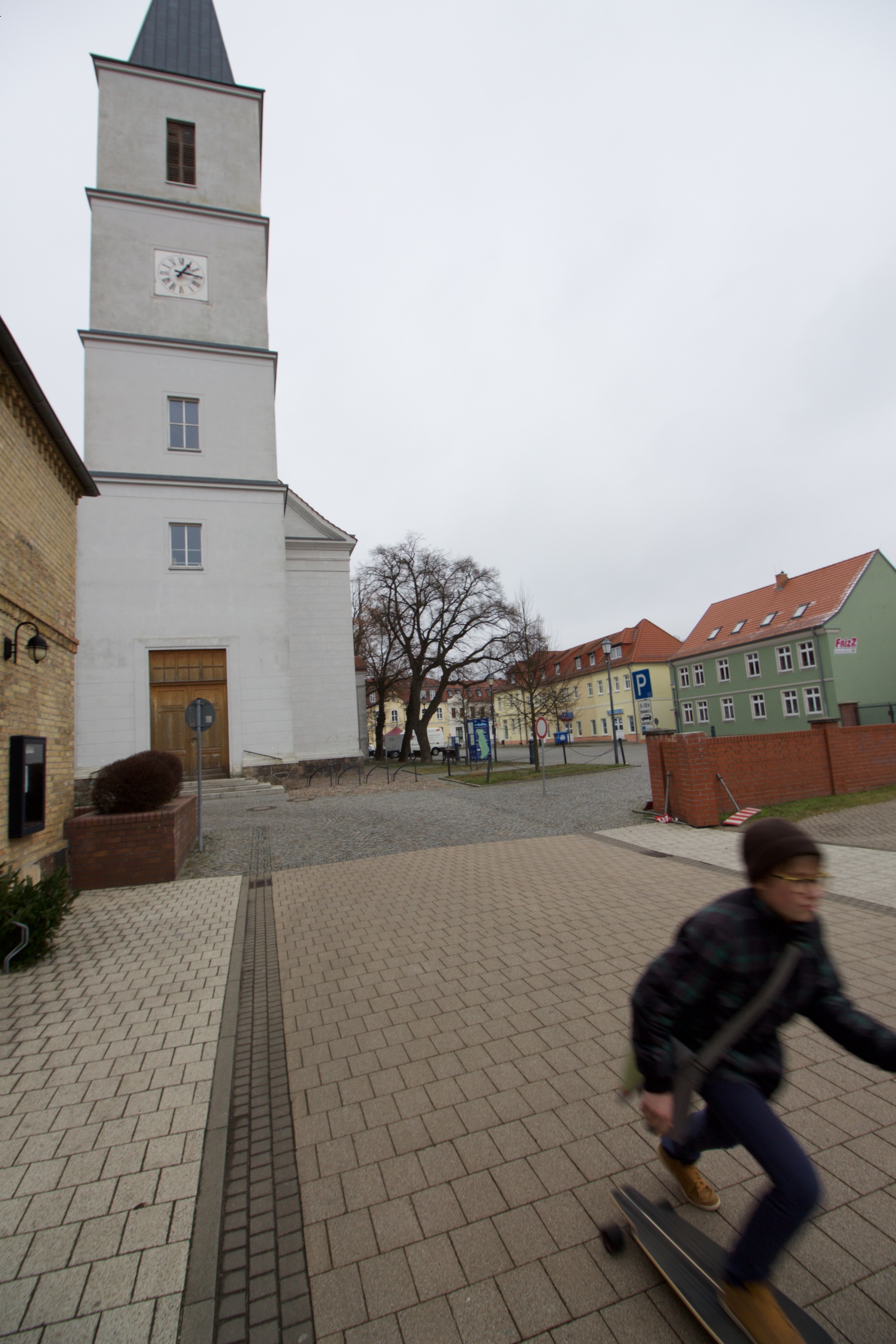
El Siglo de Oro at the Gemäldegalerie
The Berlin exhibition, showing some famous masterpieces of the era, does give a fine impression of the importance of the arts in 17th century Spain. Many works, especially from Seville and Valencia, were commissioned by the Church, such as these statues of two Jesuits.
Juan Martines Montañés and Francisco Pacheco: Ignatius of Loyola (r.) and Francisco de Borja, polychrome wood and cloth. Pic: Robin Oomkes
They show Ignatius de Loyola and Francisco de Borja, first and third Superior General respectively of the famous and powerful religious order at the heart of the Counter Reformation.
But my favourite picture must be “Mars resting”, created by Diego Velásquez while court painter to King Philip IV (1605-1665). Mars, the God of warfare, is shown in a rather despondent state. His weapons lie at his feet, and his drooping posture seems to say that he is weary of war. Would its assorted enemies, the Netherlands included, finally have gotten the better of Spain?
Ludwig Mies van der Rohe’s first and last modernist works at Berlin’s Kulturforum
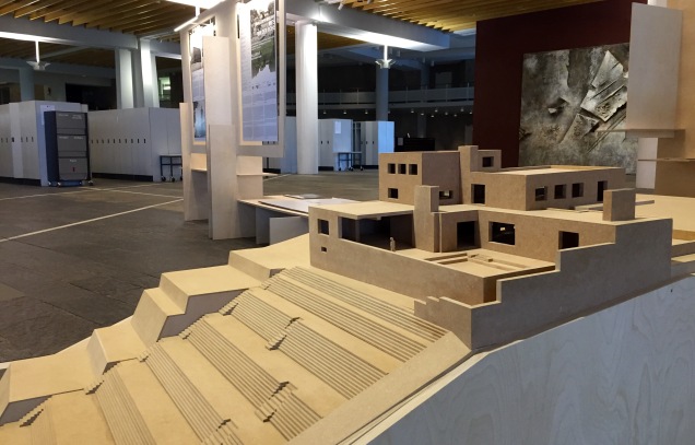
Model of Villa Wolf at Gubin, Poland. The terraces overlook the Neisse river, the post WW-II border between Poland and Germany. The model was created by students of Potsdam’s University of Applied Sciences.
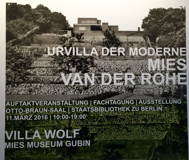
In the public entrance hall of Hans Scharoun’s Staatsbibliothek on Potsdamer Straße, there’s a temporary exhibition on a fantastic architectural project: the planned reconstruction of Ludwig Mies van der Rohe’s Villa Wolf in the now Polish town of Gubin.
Mies (1886-1969) originally trained as a bricklayer, which shows in the extensive use of the material in his early designs.
Villa Wolf, built in 1925/6, was Mies’ first modernist construction, and it is generally accepted to also be the first modernist building in the world. Bombed in World War II and never reconstructed, it is now one of those mythical places of architectural history – just like Mies’ famous Barcelona Pavillion. Created for 1929’s World Fair, Mies built the Pavillion as a showpiece of Germany’s newfound intellectual creativity after the suffocating historicismof the imperial era. It was disassembled after the show and vanished, and only photographs survived. When it was reconstructed in 1986, it drew massive attention.
Berlin’s Kulturforum. From left to right: Mies’ Neue Nationalgalerie, Friedrich August Stüler’s St. Matthew’s church, and Hans Scharoun’s Philharmonie and Staatsbibliothek.
Showing this exhibition at the State Library creates a nice juxtaposition with Ludwig Mies van der Rohe’s very last design, the Neue Nationalgalerie built in 1969. It sits just across the road from the library and also is part of the Kulturforum. Mies returned to Berlin from the United States, where he had moved in 1937 to escape the Nazis, one more time to finish this project, which can be considered as the architect’s reconciliation with Germany.
Mies’ architectural drawings of the Villa Berg have been preserved at the New York MoMA.
And that’s exactly how the sponsors of the new Villa Wolf at Gubin see the project – as a reconciliation between Germany and Poland. As was the case in Frankfurt and Görlitz, two other towns on the Oder-Neisse border, the new border created in 1945 split Gubin and Guben (on the German bank of the river) in two. But when the building is completed, it will be a monument for one of Germany’s most famous architects, sitting on the Polish side of the river but overlooking Germany. Construction is planned to start in 2017 and the rebuilt villa will serve as museum for Mies van der Rohe’s work.
Poster for the exhibition and conference at Berlin’s State Library
The exhibition at the State Library has now ended, but more information on the villa’s resurrection project can be found at www.villawolfgubin.eu.
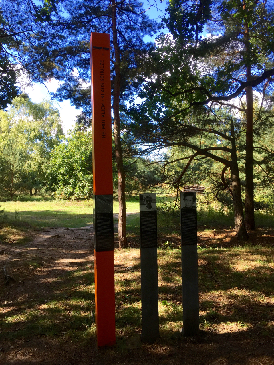
All along the Mauerweg, there are monuments for the poor souls who lost their lives trying to cross from East to West.
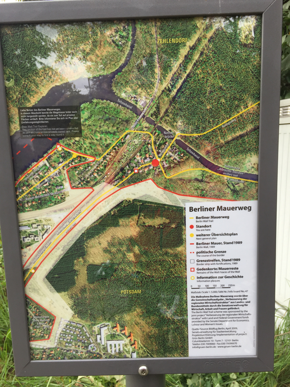
Did you know that there’s a cycle path that follows the full length of the Berlin Wall? The most dramatic part of the Wall surely was the 40 km inner-city section that divided West and East Berlin. But a much longer stretch, 125 km long, ran around the whole of West Berlin, separating it from the surrounding GDR countryside. Apart from keeping GDR citizens from entering West Berlin, it also caused a kind of claustrophobia in many West-Berliners, who could not easily leave the city. You can try to get some idea of what life was like outside and inside the Wall by taking the Berliner Mauerweg, or Wall Trail, a fully signposted cycle and hiking path that follows the course of where the wall used to be – all 165 kilometres of it.
I cycled the path in two days in September 2015, starting at the former Chausseestrasse border crossing, continuing south through the city, and following the trace of the Wall clockwise. On the first day I cycled 72 km to Potsdam-Griebnitzsee, and took the S-Bahn back to Berlin-Mitte. On the second day, from the same S-Bahn station I continued clockwise for another 95 km back to Mitte.
East and West
These signs are placed at most roads leading out of (west) Berlin. Each shows the exact date and time at which that particular border crossing opened.
Cycling the Wall 25 years after German reunification is a strange experience. First of all, it’s astonishing how little there is left of it. There are information panels on the path that show aerial photos of what the border strip looked like in the 1980s – sandy wasteland, watchtowers, outer wall, inner wall… almost all of this has gone. On 125 km of Mauerweg outside the city, I’ve spotted two remaining watchtowers, and a few slabs of inner and outer wall – that’s it. (If you’re looking for that kind of thing, you might as well stick to the inner city). The no man’s land of the death strip is either overgrown, built up, or otherwise disguised. Again, there’s only a few places where it is immediately recognisable.
Sign shown the original layout of the inner and outer walls and the death strip.
What’s also strange is how hard it has become here to tell East from West. If you’ve been to Brandenburg towns outside Berlin (Oranienburg, for example), you probably agree that they still look very “GDR” in places. But on my clockwise run down the path that straddles the West-Berlin border, I had to keep reminding myself that “left is East” and “right is West”. The bits that run through nature of course look neutral. And in the parts where you ride through built-up areas, the houses on the eastern side are often just as nice (often because they’re newer) as the ones in the former West.
Cherrypicking or the Full Monty?
Obviously, doing the full Wall ride is satisfying in itself. The trouble is that if you want to do it justice, and also take some time for photography or reading the many explanatory signs, you’ll need three, maybe four, rather than just two days.
So if you have limited time, or are not keen on two full days of cycling, or want to experience more of what you see en-route, I would recommend cherry picking some stretches. Here’s the two that I liked best: one is the inner city bit that many guided tours also follow (partially or fully): starting at Bornholmer Strasse crossing in Prenzlauer Berg, the first border crossing to open on the night of 9 November 1989, and continuing as far south as, let’s say, Treptower Park.
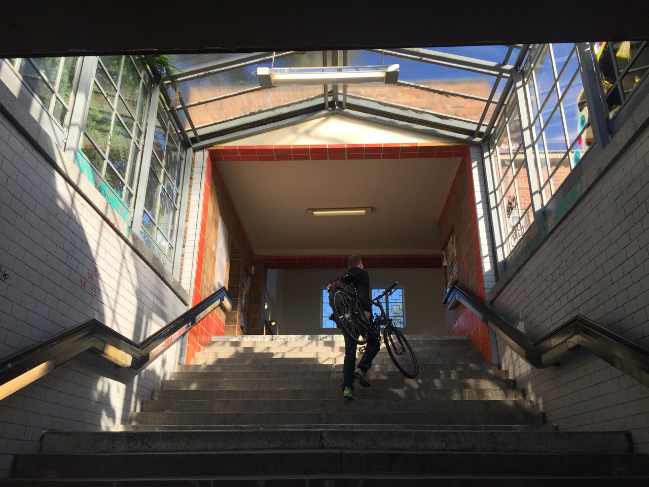
In many S-Bahn stations (like here at Griebnitzsee), you have to carry your bike to the platform.The Mauerweg takes you right past the Heilandskirche, built in 1844 after sketches by King Frederick William IV of Prussia
As for the country part of the Mauerweg, my favorite part starts at Potsdam Griebnitzsee S-Bahn station, which is right on the Wall Trail, and can easily be reached from Mitte on S7 and S1. There’s a bike (and canoe!) rental place right at the station. Continue northward, and you’ll cross Glienicker Brücke (famous for its Cold War spy exchanges), and ride through the park of Cecilienhof Palace. It’s a great way to explore the UNESCO Potsdam Havel area. The path traces the Havel lakes, past the lovely Heilandskirche (Church of the Redeemer), and then there’s a long forest ride. The first opportunity to put you and your bike back on a train to Mitte is at Berlin-Staaken railway station. The distance is roughly 35 km. Or you could turn around at the church and make your way back to the bike rental place at Griebnitzsee.
What bike?
Tree roots have caused the tarmac surface to break up, causing a bumpy ride.
Some people say you need a mountainbike to ride the Mauerweg. That’s not strictly true, although if you have one, go for it. The thing is, the path is quite good (for a 165 km initiative), but not that good. The tarmac, for example, is broken by tree roots in many places which makes for a very choppy ride. There’s stretches of gravel, which I like, some sand, which is OK depending on recent weather and your tyres, and a few kilometers of cobble stones, which are terrible. All of these problems are ok for short distances but if you want to complete the loop they can get very tiresome.
The southern half is not very hilly, but I did about 400 metres of climbing on the northern section (mostly short, steep hills). So if you can get your hands on a bike that has front suspension (for the bumps) and gears (for the hills) that would be good. Unless you have the stamina of a Paris-Roubaix racer, road bikes (Rennrad in German) are not suitable, not to speak of fixies (but then, they’re not actually for riding, are they?) Obviously bring a tyre repair kit (Flickzeug, one of my favourite German words) as most of the time, it’s a heck of a long walk to the nearest S-Bahn station or bike shop.
Catering
This little bakery in Zehlendorf was the first eatery I came across, 40 km after leaving Berlin at Treptow.
Which brings us to food. My app says I used about 4000 calories for the whole ride (with a 20 km/h moving average, which is not that fast). That’s the equivalent of 40 bananas or 8 Big Macs, none of which you can buy on the trail. There are some shops and cafes here and there, but outside the city, there are many stretches where you can ride for 30-40 kms without getting to a food outlet. You could interrupt your ride and cycle into the city to find food, but it’s probably better to bring lots of fruit and sandwiches.
Navigation
The Mauerweg signs put up by the Berlin Senate. They even have official Umleitung (deviation) signs, bless them!
To find my way around, I mainly just used the official signs. I also had a GPS on my handlebars, which was nice as a backup, and as a warning for upcoming turns. You can download my gps .gpx track here. A map is great for getting your bearings in the grander scale of things (the Mauerweg has so many twists and turns that it’s easy to get disoriented). The PublicPress map is cheap, durable, and, importantly, clearly shows S-Bahn stations, so you can always find your way back home. One side of the map shows the full Mauerweg, the other side shows an enlarged segment of the city centre. It’s also got some text explaining the sights along the way. Highly recommended.
The Berlin Wall Trail near Hennigsdorf. One of the few places where the former death strip still looks original.
So – the only thing left to do is actually do it. Stock up on food, pump up those tyres, and off you go. Just start riding, see how far you get (there’s plenty of S-Bahn stations in the first 20-30 kilometres to cut your ride short if you want to). There’s space in the comments for your experiences!
Toen ik op een mooie zondagochtend aan mijn racefietsrondje vanuit Berlin-Mitte begon, moest ik even wachten bij het stoplicht op de kruising van de Gustav-Adolf-Strasse en de Langhansstrasse in Weissensee. Vanaf het bankje van haar rollator, geparkeerd voor de bakker, sprak een nette oude dame me in het Duits aan: “lekker weertje om te fietsen, hè meneer?” Ze vroeg of ik Berliner was, en toen ze hoorde dat ik uit Nederland kwam zei ze stralend: “Ik ook!”
Inge (links, 87) en Irma (90) voor hun oude huis aan de Gustav-Adolf-Strasse 17 in Weissensee
Toen wilde ze weten waar ik in Nederland vandaan kwam, en voor ik het wist had ik m’n racefiets geparkeerd om het levensverhaal van Irma Heinis-Walter, want zo heet ze, aan te horen.
Irma, dit voorjaar met een groot feest 90 geworden, logeert een paar weken in Berlijn bij haar al even pronte zuster Inge (87), die zich al gauw met haar eigen rollator bij ons voegde, af en toe het hoofd schuddend over haar zuster, die er blijkbaar vaker genoegen in schept met wildvreemden over haar belevenissen te praten.
Kruising van de Gustav-Adolf-Strasse met de Langhansstrasse in Weissensee
Irma leerde in 1945 haar Nederlandse echtgenoot in Berlijn kennen. In de chaos vlak na de oorlog was ze blij een baan als stenotypiste op het Nederlandse consulaat in Zehlendorf (in de Amerikaanse sector) te bemachtigen. Tot 1947 werkte ze op het consulaat, want toen kon haar man een goede baan bij de PTT in Nederland krijgen. Ze verhuisden naar Noord-Holland, waar ze drie zoons kregen. Eén van die zoons, niet toevallig leraar Duits geworden, heeft haar overigens voor de logeerpartij bij haar zus met de auto naar Berlijn gebracht.
Mevrouw Heinis-Walter vertelt dat ze omstreeks 1950 erg veel last van heimwee kreeg – naar Berlijn en naar haar familie. De DDR was toen net gesticht en visa waren heel moeilijk te krijgen. Toch deed ze een poging: omdat de reis vanuit Nederland door de Franse, Britse, én Russische bezettingssector zou lopen regelde ze vanuit Nederland visa voor al die gebieden. Tegen de wens van haar man in overigens, die (terecht, zoals later zal blijken) bang was dat zijn vrouw, eenmaal in Berlijn, niet meer terug zou kunnen komen.
Tot Marienborn verliep de reis voorspoedig, maar bij de grenspost aldaar wilden de DDR-autoriteiten mevrouw Heinis, met haar Russische visum, niet binnenlaten. Misschien omdat de DDR, zo kort na haar oprichting in 1949, haar tanden extra wilde laten zien?
Wat volgt is een verhaal dat John le Carré waardig is. Mevrouw Heinis, toen 25, zocht een eind verderop een landweggetje op, en wandelde zo illegaal de DDR binnen (de muur zou immers pas in 1961 gebouwd worden). Een vrachtwagenchauffeur gaf haar een lift naar Berlijn en zo klopte ze op een avond bij haar familie in de Gustav-Adolf-Strasse aan de deur.
Dat gaf natuurlijk consternatie, want als de Stasi erachter kwam dat haar familie onderdak verleende aan een illegale immigrante zouden ze in grote problemen komen. En bovendien kon Irma, vanwege het ontbreken van het juiste visum, ook niet zo maar meer terug over de grens naar het westen. Ook haar oude werkgever, het Nederlandse consulaat in Zehlendorf, kon officieel niets voor haar doen. Maar gelukkig wist één van haar oud-collega’s daar een ticket voor haar te bemachtigen op een vlucht van Tempelhof naar Hamburg. De kosten, 200 mark, moest haar Nederlandse familie voldoen op Schiphol. Zo vloog ze vanuit Berlijn terug naar het westen, waar ze de reis met de trein kon voortzetten.
Het winkelaanbod is in het oude buurtje van de zusters wel veranderd sinds de Wende…
Nu is alles anders. Zowel Irma Heinis als haar altijd in Duitsland gebleven zuster Inge zijn weduwe, en haar zoon brengt haar met de auto naar Berlijn als ze zin heeft om haar familie te zien. Inge en Irma wilden nog wel even poseren voor de deur van Gustav-Adolf-Strasse 17, het huis waar Irma kort, en Inge bijna haar hele leven gewoond heeft. Inge zegt: “mijn vader is hier gestorven, mijn moeder is hier gestorven, mijn man is hier gestorven, en ik sterf een stukje verderop” – ze heeft een paar jaar geleden een betere woning gekregen, een eindje verderop in de straat. Het was een voorrecht met de dames te spreken – wat heb ik als nieuwkomer in Berlijn (zelfs al was ik hier in 1992 voor het eerst) toch maar weinig van de geschiedenis van de stad meegemaakt!
Naschrift: om mevrouw Heinis dit verhaal te kunnen laten lezen, heb ik via internet contact gezocht met haar zoon. In zijn reactie noemde hij zijn moeder en tante ‘wandelende geschiedenisboeken’. Dat vond ik een mooie definitie van ‘oral history’, het vakbegrip onder historici voor het optekenen van ervaringen uit de mond van mensen die een gebeurtenis zelf hebben meegemaakt. Vaak een race tegen de tijd.
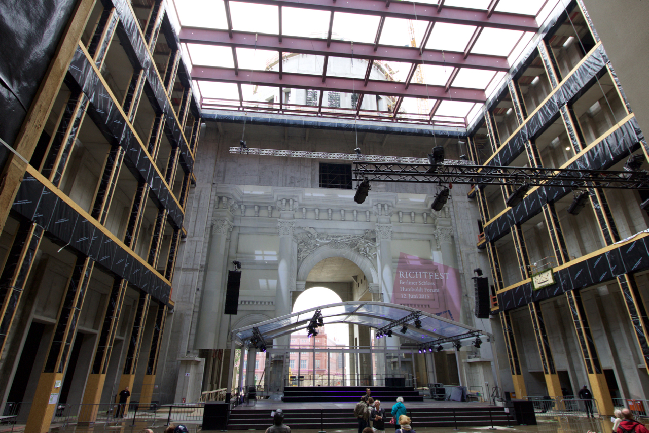
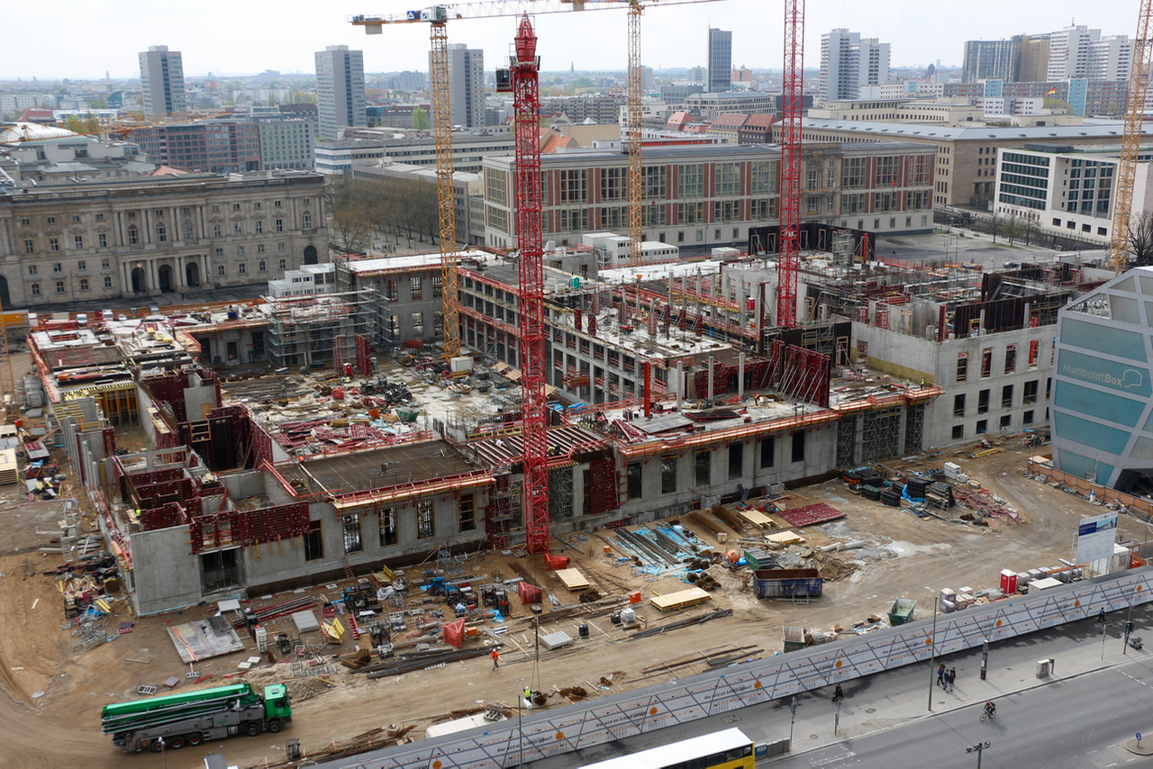
On 12 June 2015, Berlin’s new City Palace celebrated its topping out ceremony. Main entrance hall and cupola.
Celebrating ‘Richtfest’, reaching a building’s highest point, is a German tradition. In the case of Berlin’s new Humboldt Forum, which we’re not supposed to call City Palace, the party arrived sooner than everyone thought, as the project is, shall we say, controversial. Many ostalgians prefer its predecessor, the GDR’s Palace of the Republic, ‘an architectural atrocity with orange windows and asbestos inside’, to quote The Economist. It was razed to the ground in 2008 to make way for the new City Palace Humboldt Forum.
The Palace of the Republic in 1997, just before work started to remove its 5000 tonnes of asbestos. Pic: dpa.
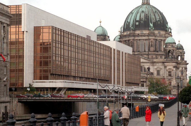
The historical to-and-fro on this site is ironic: first there was the old City Palace, built by Andreas Schlüter and Eosander von Göthe around 1700. Last monarch to occupy it was Wilhelm II, who fled into Dutch exile in 1918. Heavily bombed in World War II (but not unsalvageable), the government of the GDR considered the palace such a poignant symbol of Prussian tyranny that they blew it up in 1950 – keeping only one part: the ‘Liebknecht portal’ which contains the balcony from which Communist leader Karl Liebknecht proclaimed the German Soviet Republic on 9 November 1918. The portal was integrated in the Staatsrat building, Erich Honecker’s office, just across the road from where the palace had been. Then, in the 1970s, the GDR’s bronze glass and asbestos Palace of the Republic was built on the site previously occupied by the City Palace. As the GDR itself got confined to history, so did the Palace of the Republic, and things went full circle as construction of the new Humboldt Forum, a replica of the old City Palace, is now halfway completed.
Looking out at the old City Palace’s Liebknecht portal, integrated in the GDR’s Staatsrat building
Funding of the Humboldt Forum project has always been precarious. In the end, the German federal government agreed to foot the bill for the new ethnology museum that the palace will house and which had to be built anyway. But the cost of the baroque stonemasonry that will make the building look like its 1702 predecessor has to come from private funds, and the money isn’t fully there yet – hence the hearts and minds (and money) exercise organised over the weekend of 12 to 14 June 2015. If all goes well, ironically, Berlin will have two Liebknecht portals (one on the Staatsrat, one on the Humboldt Forum), but no more communism.
This is how far construction had proceeded on 7 April 2014 – just 14 months before topping out. Good views of the Palace’s neighbours: Marstall (Palace Stables), Staatsrat (GDR Upper Chamber) and Auswärtiges Amt (Foreign Office)
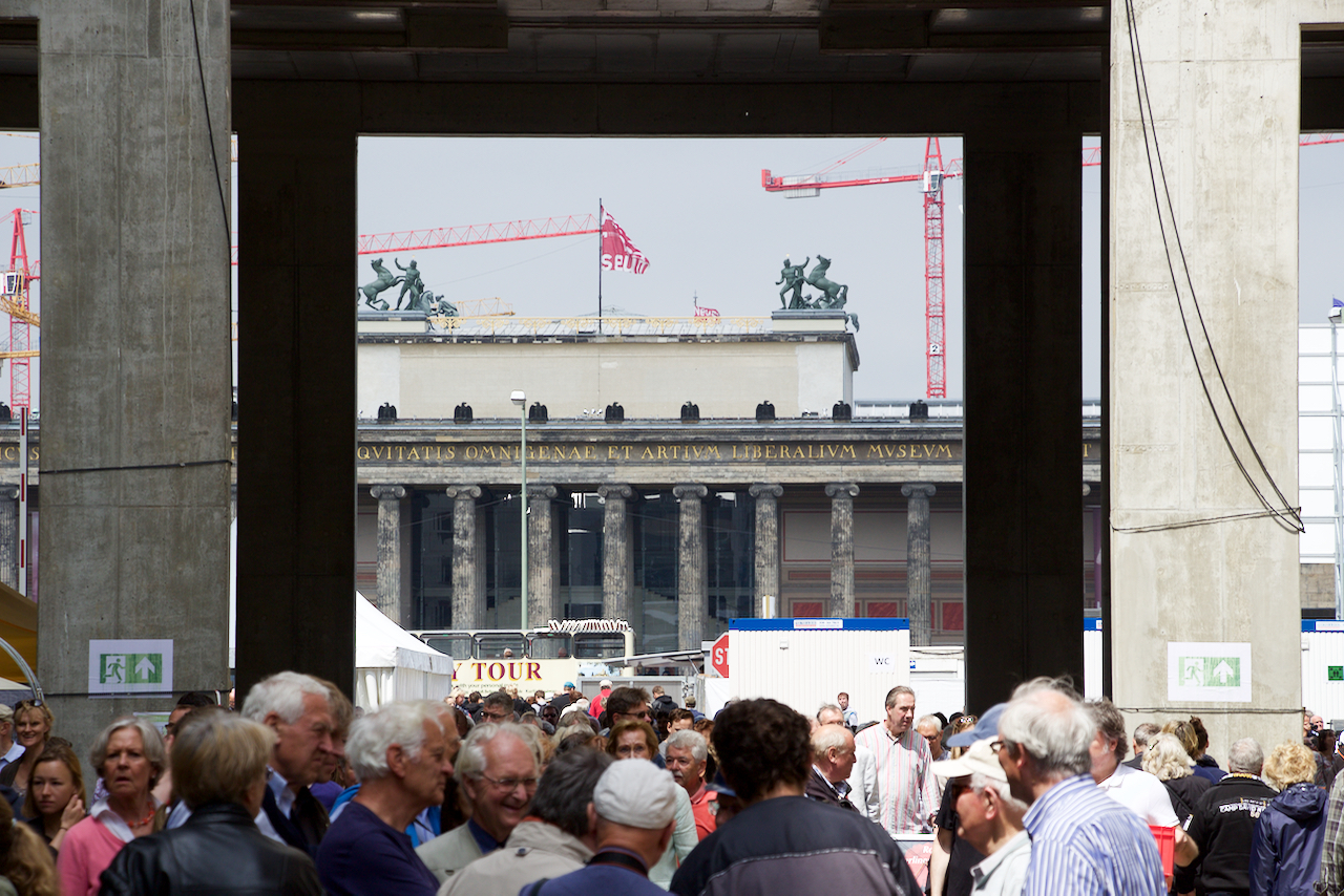
Most of the thousands of visitors to this weekend’s open house looked like Berliners – they certainly were different from the hordes of tourists in shorts and sunglasses hanging out in Lustgarten outside. Most people were over 50, conservatively dressed – West or East Berlin, or from outside the city? Hard to tell.
The building’s rough shell was interesting enough – but the views of its neighbours, like the Altes Museum, were spectacular.
The fundraisers for the palace’s completion got ample exhibition space, but the open house wasn’t a begging exercise – access was free, and the collection boxes weren’t that conspicuous. If anything, the Humboldt Forum’s partners got pride of place. On each corner of the building, the neighbours got the opportunity to present themselves – the German Historical Museum across the road on Unter den Linden, the project to reconstruct Schinkel’s red-brick Academy of Architecture, the Foreign Office, the management institute that occupies the GDR’s former Council of State, and so on.
Schinkel’s Bauakademie, currently faux cloth on scaffolding, may be Berlin’s next historical reproduction…
Students from the Hanns Eisler music academy, which is housed in the Marstall, the stables and service building of the old City Palace, played jazzy big band tunes which fitted right in with the visitors’ demographics.
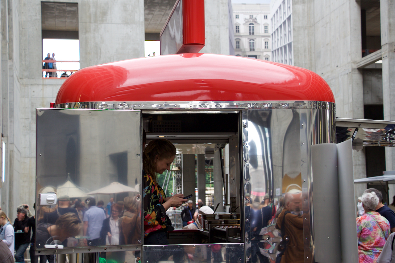
Although touring the second floor would find you some non-standard catering, including an Israeli falafel stand, the main entrance hall of course contained the staple of any German festival: a bratwurst stand and a beer wagon. So far, so traditional.
Can’t have a serious party without a bratwurst stand.
Hard to say when the next time will be Joe Public can go see the City Palace. Maybe it will only be by the time the Humboldt Forum actually opens – and Neil McGregor, current director of the British Museum, connoisseur of all things German and curator of the excellent ‘Memories of a Nation’ exhibition, will have woven his magic wand over the Forum’s concept and content.
Many displays showed how the building’s external stone masonry will be recreated – failing actual masonry, screen- printed cloth had to do!
The Langemarckhalle – Hitler’s link between soldiers dying in WWI trenches and the 1936 Olympic Games
Follow the Strasse des 17. Juni all the way west from Brandenburg Gate and after about 10 km you will find yourself in the leafy area of Berlin’s West End. There are two poignant war memorial sites here: the 1936 Olympic complex with its Langemarck Hall, honouring the German dead of World War I, and the 1939-1945 Berlin Commonwealth War Cemetery.
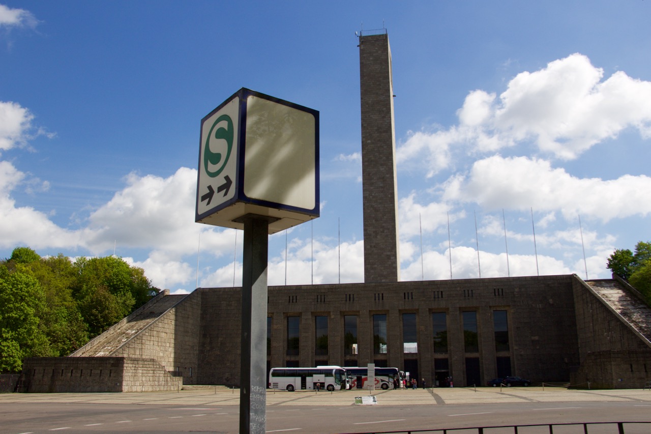
Berlin’s sports complex for the 1936 Olympics and the Langemarck Hall
Berlin’s huge Olympic site in the West End is one of those projects, like the Autobahns, that are usually credited to Hitler but which were actually conceived in the era of the Weimar Republic. Hitler knew a good idea when he saw it but would normally add his own perverted twists.
1936 map of the Reichssportfeld. Much of the site remains as shown here.
In the case of the Reichssportfeld, this involved turning the original design for the Olympic Stadium, which was Bauhaus-inspired with lots of steel and glass, into the traditional Nazi design language of forbidding stone cladding and intimidating Doric columns.
Hitler also added the Maifeld to the west of the stadium, a huge parade ground where the Party could marshal hundreds of thousands of people for mass gatherings, and an amphitheatre for open air performances (known as Waldbühne today and still used for performances). Then there was the Olympic Bell Tower (Glockenturm) overlooking the Maifeld and the Olympic Stadium (and much of the rest of Berlin besides – very much worth a visit!).
Maifeld grandstands and Olympic Belltower. Fuhrer’s Lodge can be seen at the base of the tower.
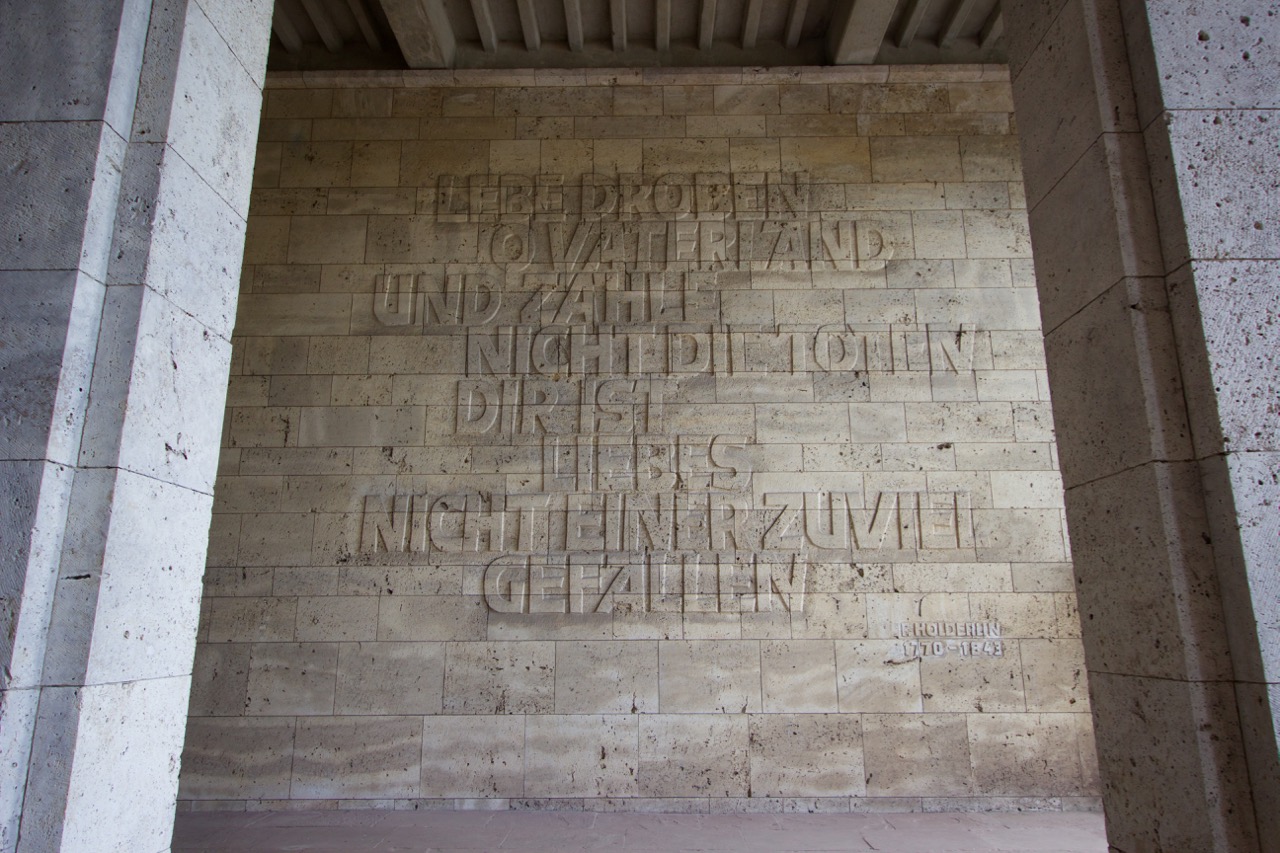
But the structure most telling of Hitler’s belligerent intentions, already as early as 1936, was the Langemarckhalle, at the base of the Bell Tower. Langemar(c)k is the name of a Flemish village near Ypres, where one of the first entrenched battles of World War I took place in October 1914. Many young German volunteers lost their lives, and in Germany the name became symbolic for the horrors of war but also for the heroism of the soldiers who died.
View over Berlin from the top of the Glockenturm
The Nazis used Langemarck in their propaganda whenever the topic of World War I arose – which it frequently did, as the platform on which the NSDAP had come to power was the shame of Germany losing WW I, and the Stab-in-the-back myth of Socialist and other mainstream parties agreeing the November 1918 armistice, where, if left to fight on, the German army could have won the war .
Friedrich Holderlin’s 1799 quote on sacrifice for one’s country – taken out of context by the Nazis – adorns one of the Hall’s walls.
But in the runup to the 1936 Olympics, Hitler took Langemarck propaganda one step further in creating a direct link between sportsmanship and the heroism of fighting and dying in battle. By building this rather grim memorial to the dead of World War I at the centre of the Reich’s most prestigious sports facilities, he managed to frame the Olympics, for the German population at least, as a kind of preparation for the struggle to come.
Outside view of Langemarckhalle, at the base of the Glockenturm
The 1939-1945 Berlin War Cemetery
The modest entry path to the Commonwealth Berlin War Cemetery on Heerstrasse
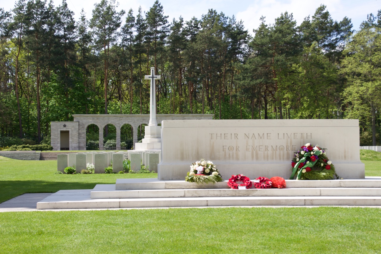
A different, and far more peaceful, kind of war memorial is the 1939-1945 Berlin War Cemetery, managed by the Commonwealth War Graves Commission. Just over a kilometre away from the Bell Tower, at the northern edge of Grunewald forest, this site is the central burial place for British and Commonwealth airmen killed over Eastern Germany, as well as for killed prisoners of war.
Most of the fallen at this cemetery were bomber crews – the survival rate of flying staff in the R.A.F. was only 44%. Crews lie buried together whenever possible. The cemetery was opened in 1945 and bodies of airmen were soon collected from all over Eastern Germany to receive their final resting place here, in what was then the British sector of West Berlin.
Commonwealth War Graves Commission gardeners tend to the cemetery.
Visiting the cemetery is a familiar experience for anyone who has been to a Commonwealth war cemetery anywhere else – the same headstones, the same simple descriptions of rank and date of death, and often an inscription chosen by the dead man’s relatives. The grass and flowers are meticulously kept by the cemetery’s groundsmen, and the atmosphere is very much one of peace – sadness yes, but definitely peace, and gratitude for those that gave their lives.
“Their name liveth for evermore” – Rudyard Kipling, who lost a son in World War I, was asked by the Commonwealth War Graves Commission to choose a suitable text for use in the cemeteries. He chose this quote from Ecclesiasticus.
There couldn’t be a more different approach to honouring a country’s fallen soldiers than between the Langemarckhalle and the Berlin War Cemetery. Visiting them together makes for a fascinating half day away from the bustle of central Berlin. The stark contrast between the two memorials is a great reminder of the power and the dangers of propaganda, and clearly shows the difference between how democratic and totalitarian countries come to terms with their history.
A Red Army T34 tank at the Seelow Heights Memorial and Museum
In the first half of 2015, Europe celebrates the 70th anniversary of the end of World War II. On an almost daily basis, you can follow the Allies’ progress across occupied Europe by following commemoration events – from the liberation of Auschwitz on 27 January to the Battle of Berlin from 20 April onwards, and the final surrender of the German High Command at Berlin-Karlshorst on 8 May. (Use Liberation Route Europe’s excellent app – LRE in your app store – for details on the route).
Even with Germany over 50% occupied by Allied forces by February 1945, and no realistic hope of a military victory, Adolf Hitler and his staff showed no signs of surrender, instead preferring to fight to the bitter end – bringing country and population down with them (read Ian Kershaw’s excellent The End for an analysis of why they might have done that). To force a surrender, the Allies had to conquer Berlin. The job was left to the Soviet forces advancing from the East, and the first step was the Battle of Seelow Heights.
Road tripping the B1
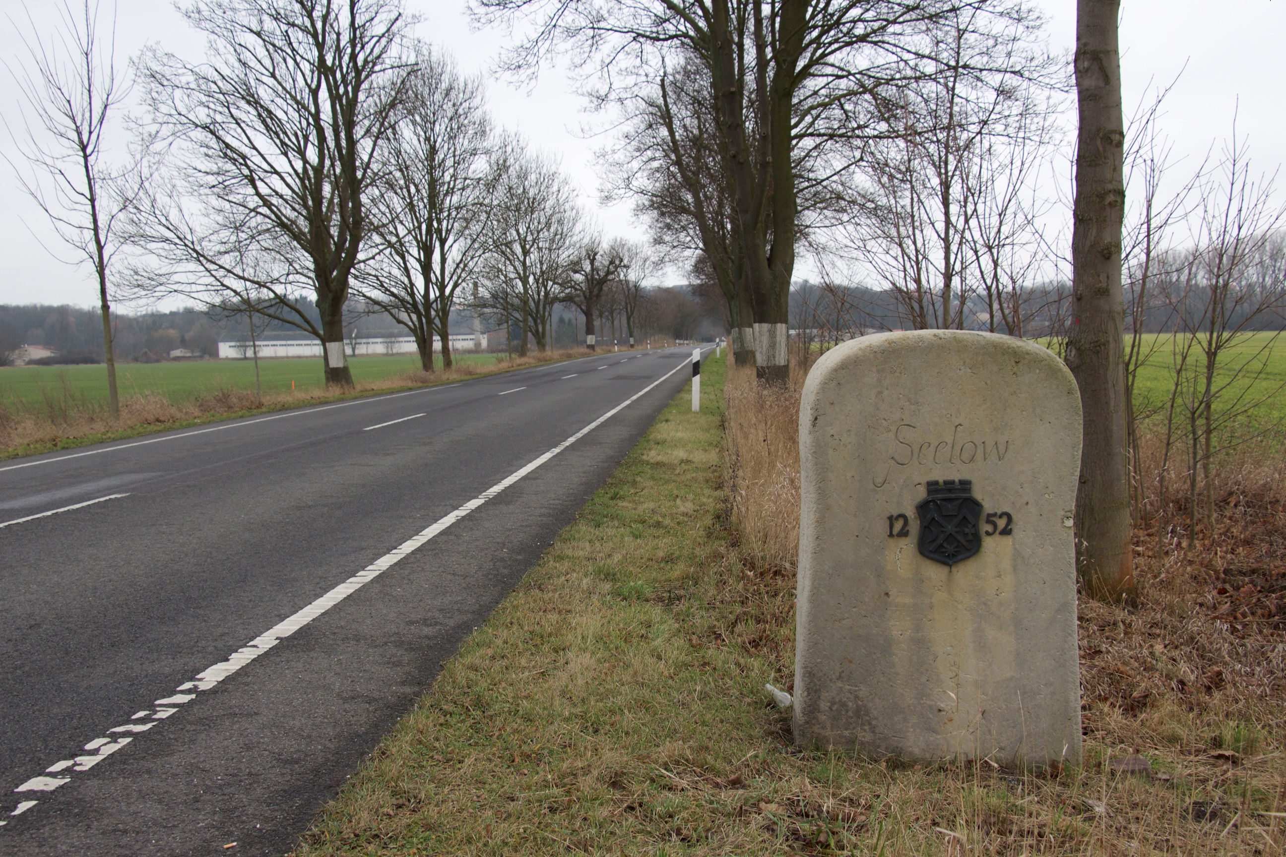
I decided to go and see the battlefield. Seelow is a small market town on the B1 road, close to where it crosses the Oder River. The B1 used to be Reichsstrasse 1, which once ran all the way across Prussia, some 1300 km from the Dutch border at Aachen in the west to Königsberg (today’s Kaliningrad) in the east. (It actually shares its roots in middle Germany with the Westfalischer Hellweg, which dates back to Charlemagne. But that is another story).
The B1 road from Berlin to Seelow – Prussia’s mother road
There’s trains to Seelow, but driving the road that the Red Army needed to secure for their final assault on Berlin does add to the experience. Berlin to Seelow is easy – just point east on Karl-Marx-Allee and keep going. It takes about 90 minutes and takes you across a varied landscape – after the GDR high rises of Marzahn, the road continues as a 4-lane highway up to Berlin’s outer ring road (A10) – but the cityscape quickly changes to typical one or two storey Brandenburg farm houses – interspersed with a variety of not too prosperous looking businesses.
B1 near Rüdersdorf
Once you’re across the A10, the road narrows to two lanes, and the country becomes slightly hillier, with the occasional S-bend in the road. It also passes the Nature Reserve of “Märkische Schweiz”, an example of the strange German custom of calling any area that is slightly hillier than the surrounding landscape “Switzerland”.
As you approach Seelow, you can tell you’re getting close to the Polish border. In the last stand of woods before the town, even in mid-winter, there are girls sitting by the side of the road, waving at passing motorists, and chatting (to each other?) on their mobiles.
The Battle – first they took Seelow Heights, then they took Berlin
Marshall Georgy Zhukov, the commander of the 1st Belorussian Front, had been pushing back Nazi forces through Ukraine and Poland since October 1943. In January 1945, he finally reached the Oder-Neisse line, at Kostrzyn, the point where Reichsstrasse 1 crossed the river. Here, his armies kept their position in the floodplain of the Oder river, only 70 km from Berlin’s Alexanderplatz, waiting for other Soviet army units to spread to the north and south, to allow for fully encircling Berlin.
By 16 April, sufficient forces had finished their mopping-up operations further east for the final push to the German capital. General Theodor Busse’s 9th Army, consisting mainly of under-armed Hitler Jugend boys and little-trained Volksstorm fighters, had prepared its defences on a a north-south ridge in the landscape some 90 m high, flanking the Oder’s flood plain and centred on Seelow – where Reichsstrasse 1 scaled the Heights.
B1 (former Reichsstrasse 1), and the eastern approach to Seelow. The woods in the distance (approx. 1 km) are the Heights.
The attack started before dawn. The Red Army used runway floodlights to light the battlefield and blind their opponents, but in the early morning mists, they only served to backlight the advancing infantry. Pushing across the muddy floodplain up onto the well-defended heights (which, from any distance, look deceptively flat) proved to be more difficult than expected, and the battle dragged on for days, causing heavy casualties on both sides.
Detail from outdoor information sign at the Seelow Heights Museum and Memorial
Only by the fourth day of fighting, the Soviet troops managed to break the German forces’ third line of defence at Seelow, and from then on, not much stood in their way until reaching Berlin’s city limits. The Battle of Seelow Heights turned out to be the last entrenched battle of the war between Nazi Germany and the Soviet Union, with tens of thousands of losses on both sides.
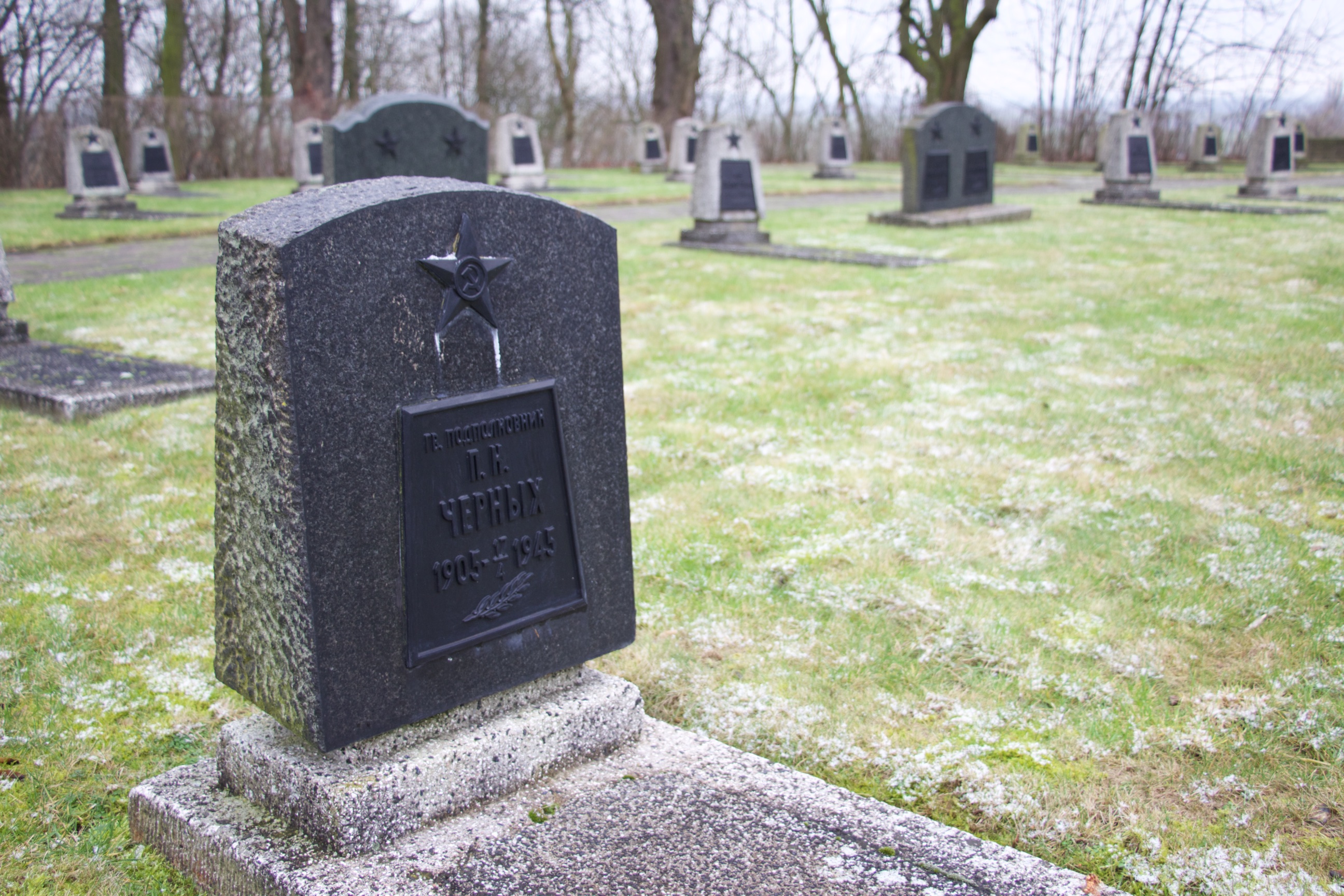
Soviet War Grave at the Seelow Heights Memorial
The Monument and Museum
After the Battle of Berlin, the Red Army wanted to honour its dead and mark its victory. Marshall Zhukov, who stayed on as military commander of Berlin and the Soviet occupation zone, commissioned three monuments immediately after hostilities ceased in May 1945: the famous Soviet War memorial on Strasse des 17. Juni in Berlin’s Tiergarten, the monument at Seelower Heights, and an obelisk at Kostrzyn, just up the road in Poland, which was removed in 2008.
Lev Kerbel’s Seelow war monument
The monument at Seelow was created by Lev Kerbel, who also designed the Tiergarten memorial. The Red Army didn’t waste time: both monuments were inaugurated in November 1945. The Seelow statue shows a Red Army soldier with his hand on the turret of a defeated German tank. From the beginning, the memorial included war graves, but most Soviet and German casualties of the battle are buried elsewhere, at Lebus and Lietzen cemeteries respectively.
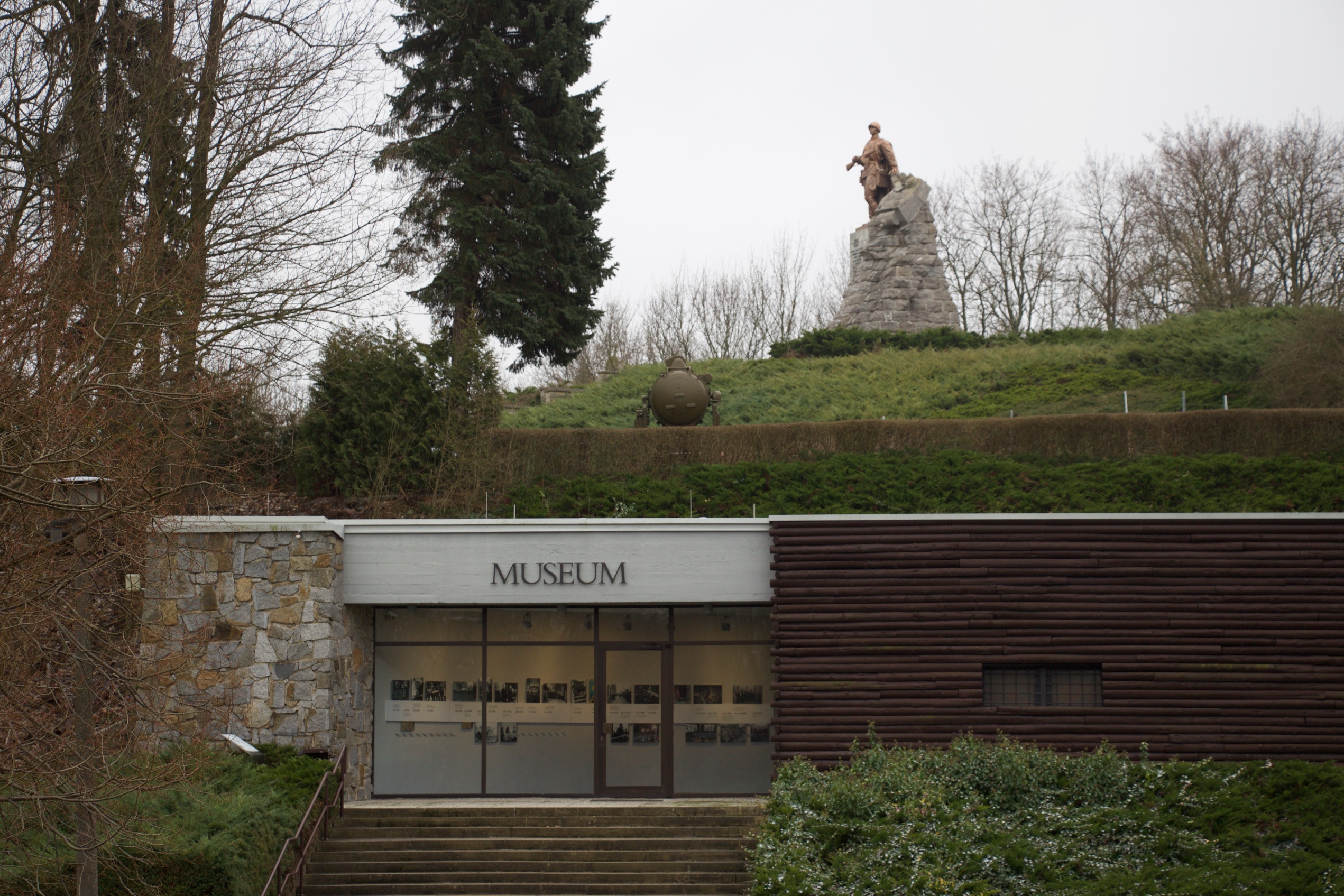
Seelow’s battle museum
The museum is worth a visit. It’s fully bilingual in German and English, and like so many monuments in the former GDR, it has an interesting history in its own right. It was built in 1972 to complement the War Memorial on the hill, and has the shape of a typical Russian bunker. It was meant to pay tribute to the Red Army, and cement the everlasting friendship between the socialist peoples of the German Democratic Republic and the Soviet Union.
The museum’s main display room
Although no one disputes the heroism of the Red Army soldiers giving their lives for the final push to rid Europe of the Nazi regime, after German reunification questions arose on the overtly political slant of the museum’s displays. The exhibition texts were rewritten and by 1995 the current displays had been created. The museum now tries to do justice to victims on either side.
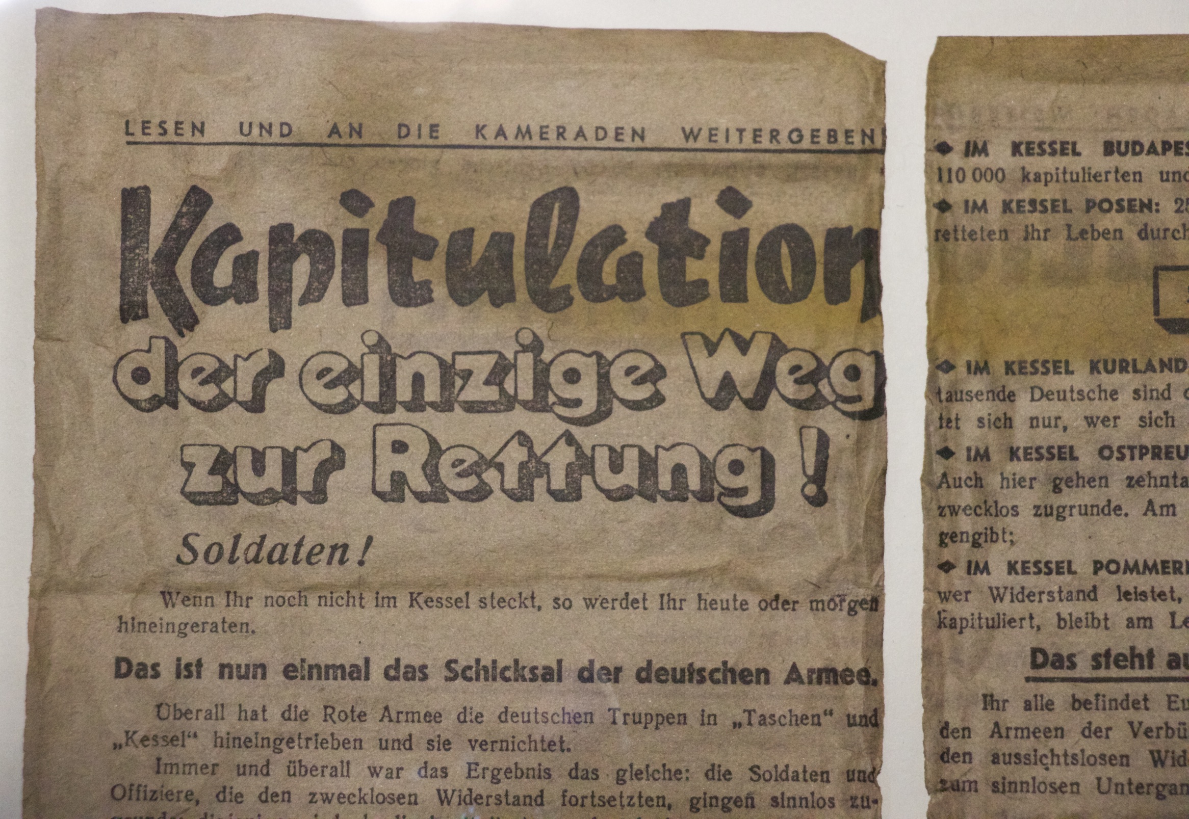
Soviet propaganda leaflets, dropped behind enemy lines, trying to get German soldiers to surrender – “Capitulate – it’s your only chance to be saved” – from the museum’s collection
There’s no catering (or other facilities) at the museum, but Seelow has a nice town square, with some cafes and restaurants to make up for it. Unfortunately, the battlefield itself, in the floodplains below Seelow, is not signposted, and there aren’t any other monuments beside the main one, so after finishing your Kaffee und Kuchen, you’re probably best off following the Red Army’s tracks back up the B1 to Berlin.
Seelow town square, with classicist church (1832) by Karl Friedrich Schinkel
How Bavarian motor bikes came to Berlin. Info display at BMW’s Spandau factory.
Today, there is not a lot of heavy industry left in Berlin. The city that once was the home of huge factories like Siemens, Borsig, and AEG never recovered from World War II. What wasn’t bombed by the R.A.F. and the US Air Force was dismantled and carried off by the Soviet, French, and British occupying forces, what wasn’t dismantled was either nationalised (in East-Berlin), or was left to die a slow death in the isolation of post-war West-Berlin.
But there’s an exception: BMW’s motorcycle factory in Spandau. Since 1969, BMW has built all its motorbikes at this site (with the exception of the original F-series 1-cylinder bike in the 1990s). Today, some 110.000 bikes leave the factory each year for shipment over the world. That may sound like a lot, but Honda, its largest Japanese competitor, builds five times as many – and that’s down from a peak of 3 million in 1982.
BMW relocated its bike production to Berlin as it was running out of space in its factories in Bavaria. But it had a long history at the site. Originally built as an airplane engine plant by Siemens in 1928 (the factory is adjacent to an area called Siemensstadt, a complex of factories and modernist flats for workers, now a Unesco World Heritage site), it was spun off as ‘Brandenburgische Motoren Werke’ or Bramo in 1936 – after all, the BMW acronym was already being spoken for. The plant built radial engines for planes such as the Junckers Ju52/3m – known throughout Germany as the Tante Ju (Auntie Ju), the German equivalent to the reliable and multipurpose DC3 ‘Dakota’.
Junckers Ju52 at Berlin’s Technikmuseum, with three 9-cylinder BMW radial engines.
By 1939, BMW, by then a motorcycle, aeroplane engine and motor car producer, acquired Bramo and continued building aircraft engines at the site. After World War II, the plant’s equipment was dismantled by the Allies. Low scale production of useful stuff like sickles and scythes continued at the factory, but it returned to full operations in 1949, constructing motor cycle parts for BMWs assembled in Bavaria.
Gate 1 of BMW’s Spandau motorcycle factory. No photography beyond this point – except for the visitor centre!
What certainly influenced BMW to bring all motorcycle production to Spandau were the lavish subsidies the Senate granted to anyone wishing to invest in West-Berlin – a sum of 200 million Marks (in 1969 money!) was granted just to redevelop the site. But whatever the original motive – the company has stayed the course, and is even expanding. It’s bought a plot of land adjacent to the factory to build a new assembly hall.
BMW’s first motorcycle, the R21 from 1923, in the visitor centre at the Spandau plant. In the background: part of the almost 100 years old machining hall, where engine parts are made.
When you take a tour of the factory (6 euros, book through the bmw.de website), you see why they need the extra space: while quaint, the long history of the factory means that it consists of a large number of smallish buildings, some from the early 20th century, and the logistics of keeping everything organised must be a nightmare.
As mentioned, the production numbers at BMW Motorrad (the subbrand’s official name) are not spectacular as far as global bike factories go – but then, as BMW likes to point out, they are a high end brand, and there’s a lot of manual labour in constructing each bike. One of the interesting things you see on the tour is how much of the work is done by hand. There’s robots for the heavy and dangerous stuff, but a lot of the assembly work is done by people who have usually entered the factory as trainees straight out of school, and are quite happy to spend their whole careers there. In Berlin terms, they are good jobs to have.
Many Berlin-based expats share a love for GDR history and architecture. And GDR architecture doesn’t come more in-your-face than Plattenbau – the prefab tower blocks that grace the edges (and often also the city centres) of many East German and other Eastern Europe towns.
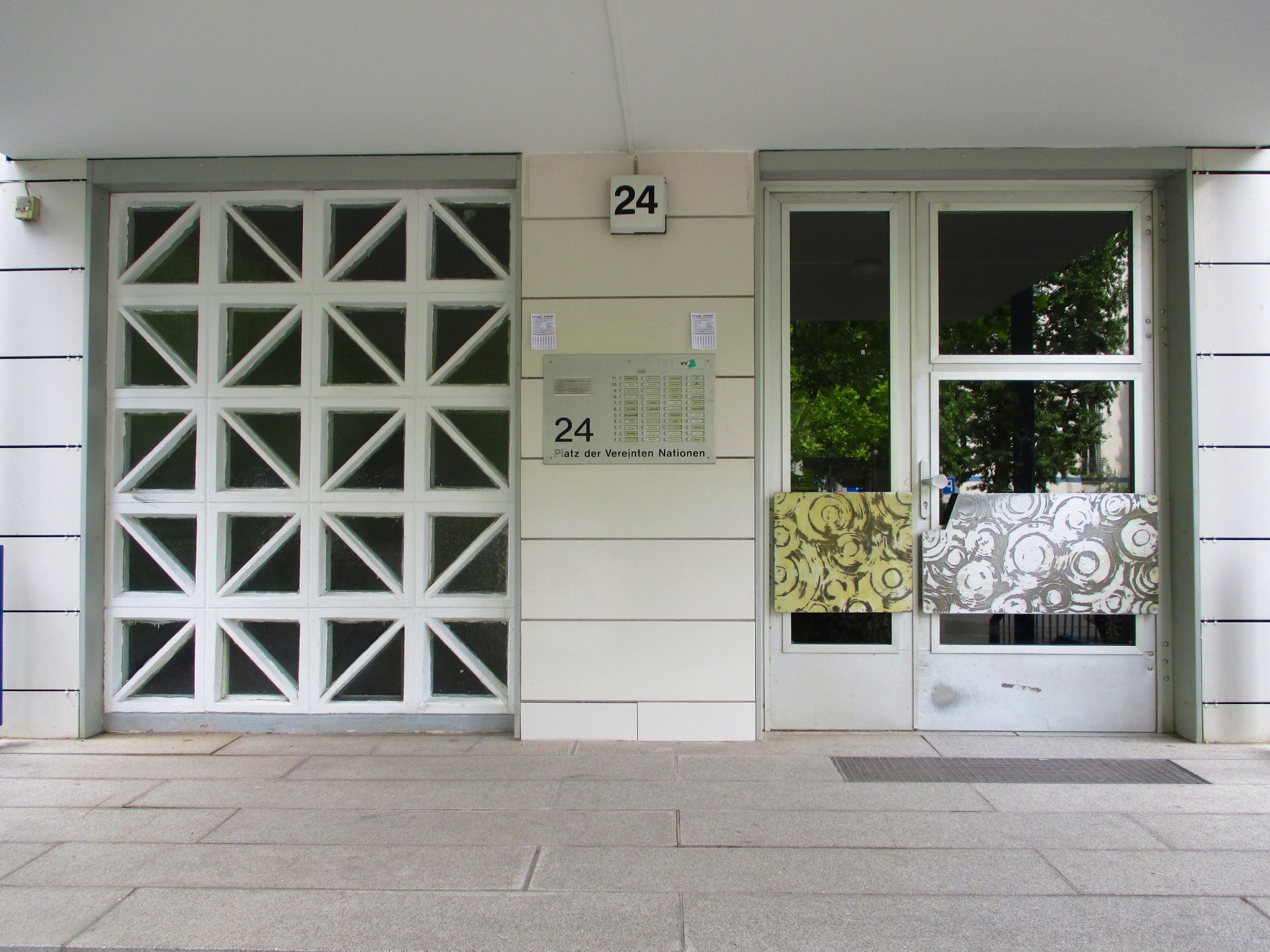
“Schlange” Plattenbau at Platz der Vereinten Nationen (ex Leninplatz)
When my 6-year old’s playmate Lukas needed a ride home to ‘Platz der Vereinten Nationen’ (United Nations Square) in East Berlin, not far from Alexanderplatz, Ijumped at the chance to visit a Plattenbau – the word literally means ‘panel construction’. As an expat who has ended up in scenic Mitte, I don’t meet that many people who live in Plattenbau buildings, as the apartments are mostly rented by people with East-German roots who don’t really mix with the professional/expat/creative crowd. So here was my opportunity.
Other side of Schlange, with doorways
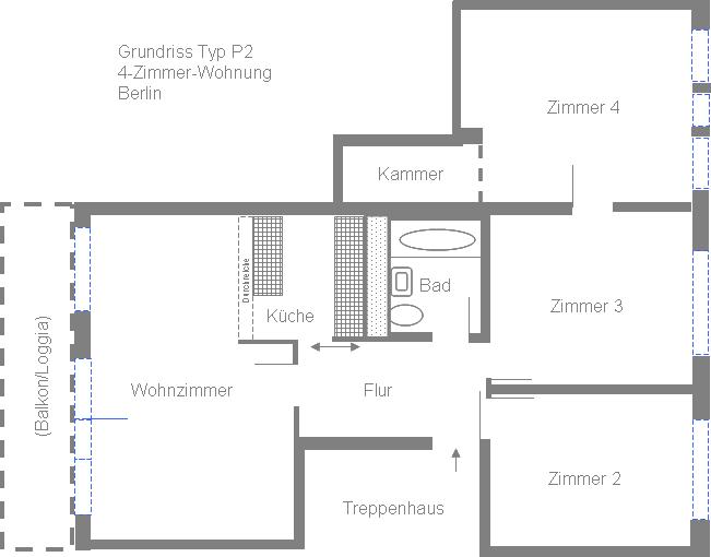
The current Platz der Vereinten Nationen (United Nations Square) started life around 1970 as Leninplatz – so, to honour the great revolutionary, this particular GDR project received a bit more thought than, let’s say, some of the rows of high-rises on the outskirts in Marzahn. Although all flats in this project are of the standard P2 and WBS70 types (trust the GDR to give innocent tower blocks military-sounding names), this was the first Plattenbau to be built in a curve. The builders developed special trapezoid prefab elements to be able to bend the building, meaning some lucky tenants have living rooms with five corners.
Original doorways
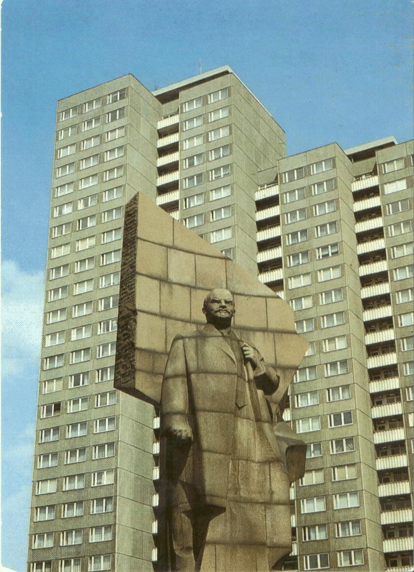
First impression: the outside of these very centrally located East Berlin apartments looks pretty ok – lots of space around the buildings, they seem to be in a good state of repair, some colourful detailing – I know social housing and council estates in the Netherlands and the UK that look worse. The entrance portals, and indeed the flats and the square itself, are protected as city landmarks. The square, a busy traffic junction, used to have an enormous Lenin monument, but it’s too late to protect that now. Removed in 1991, it gave the 2003 feel good blockbuster “Good Bye Lenin!” its name – in the movie, the monument can be seen dangling from a helicopter as it is taken down. This was poetic licence, as the actual statue was made of granite, and no helicopter on earth would have been able to lift it! All that’s left at the site of the monument today is a fountain, which somehow doesn’t fill the void left by Vladimir Ilyich.
Lenin statue at Leninplatz (dismantled in 1991), image: Wikipedia
Current fountain in same location
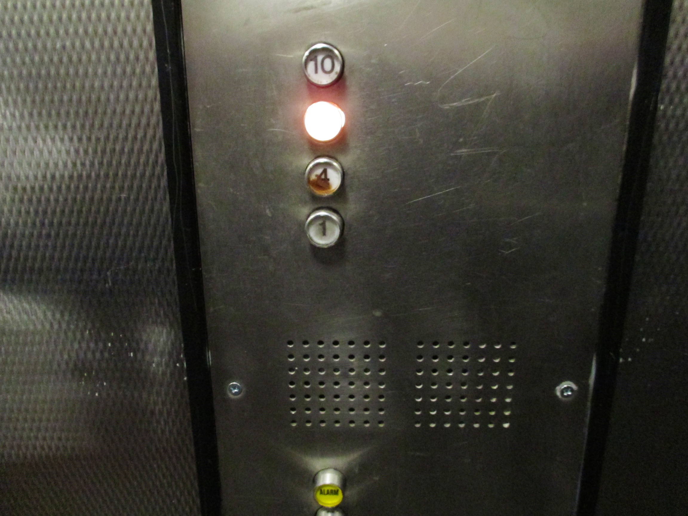
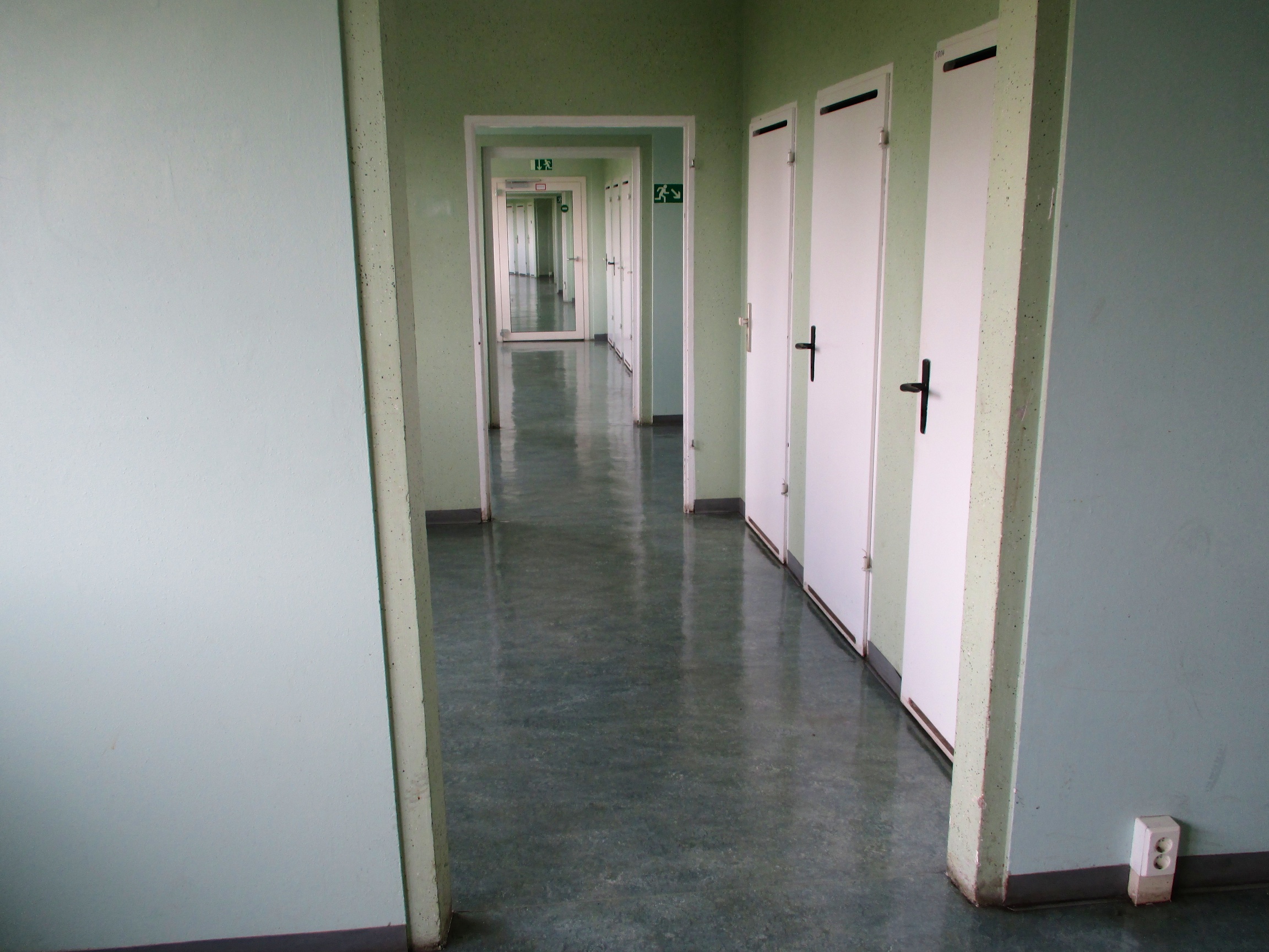
But back to the Plattenbau – my visit was to the building in the northwestern corner of the square, the ‘Schlange’, or snake – because of its curved shape, of course. Although 11 storeys high, the lifts in these buildings only stop at the 1st, 4th, 7th and 10th floors.
Lift only stops at floors 1, 4, 7 and 10
It’s almost as if the Politburo begrudged their comrades lifts that actually took them to their front doors, but from a planning point of view it makes perfect sense: Lukas’ parents’ apartment, which is on the 6th floor, has an additional bedroom thanks to the fact that there is no hallway and corridor for the lift taking up space on their floor. Their upstairs neighbour, who doesn’t have to climb the stairs to get to the lift, in fact has two bedrooms less to pay for it. Inside the apartment, it’s not that bad – again, a bit like western Europe 1960s/1970s social housing projects. I did find the ceilings a bit low, and the rooms are cramped (the apartments are made up of 6x6m squares to fit in the prefab structure). But it’s nothing that some clever decorating and furnishing can’t fix. For privacy reasons, I won’t show you pictures of Lukas’ apartment, but the good news is that the Plattenbau apartment recreated at Berlin’s DDR Museum is also a P2 – so if you’ve seen that, you’ll know what it’s like.
7th floor lift corridor – other floors have bedrooms in this space
Everything in Plattenbau design was aimed at efficiency – as we’ve seen with the lifts, not always leading to the most pleasant solutions for the tenants. The best example is the kitchen. For ease of construction, it’s good to have the kitchen and bathroom back to back, because it allows for sharing water pipes, drains and ventilation. And this is how they’re built – kitchens and bathrooms are next to each other, in the centre of the apartment. But this means that in the original layout, the kitchens only received indirect daylight, if any – through a gap in the wall dividing it from the living room. In most P2 apartments, the wall between kitchen and living room has now been removed, at the cost of a lot of cupboard space. Can’t see your cake and eat it, then.
P2 floor plan – notice central kitchen and bathroom, and additional bedroom. Image: wikipedia
Summing up, then, I was happy to see that Plattenbau apartments are not as terrible as they are sometimes made out to be. They’re small, yes, but they’re cheap to rent, and they’re not much worse than 1960s/1970s social housing in the UK, Netherlands, France or indeed ex-West-Germany.
What you can hold against them is that the drive for efficiency sometimes went too far: the kitchens without daylight, the floors without lifts, and, let’s face it, the sheer ugliness of most of them. On the plus side, Lukas’ parents told me there’s a real sense of community in the Plattenbaus, with children sometimes settling only a few blocks, or even a few floors , away from their parents. And, in the case of ex-Leninplatz, in the centre of East Berlin, the location is perfect.
We visited Berlin’s Technology Museum for our son’s 6th birthday. We only had time for the aeronautics section and the trains – but I had my aha moment, and the boys loved the museum.
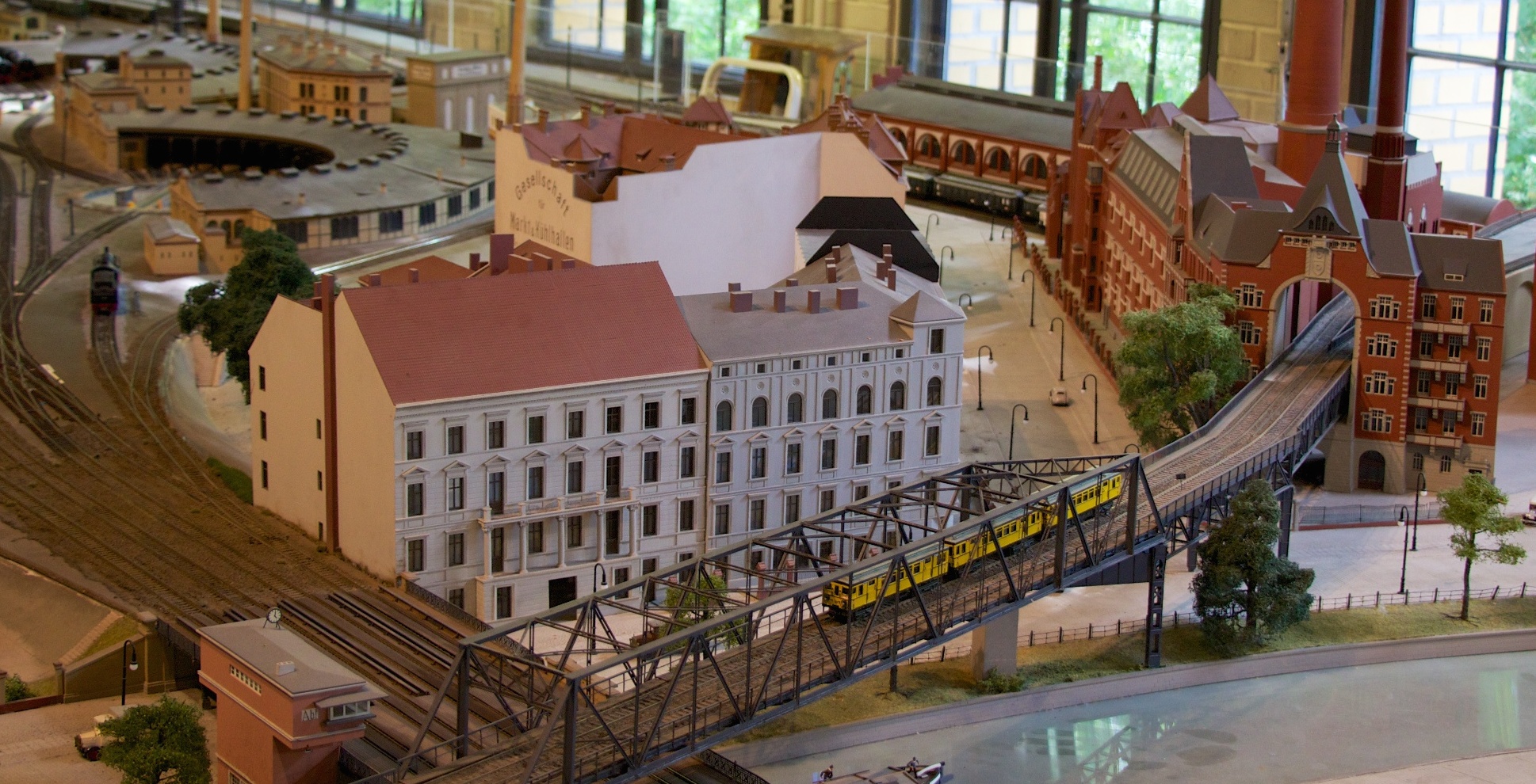
Model of the current site of the Technikmuseum with U1
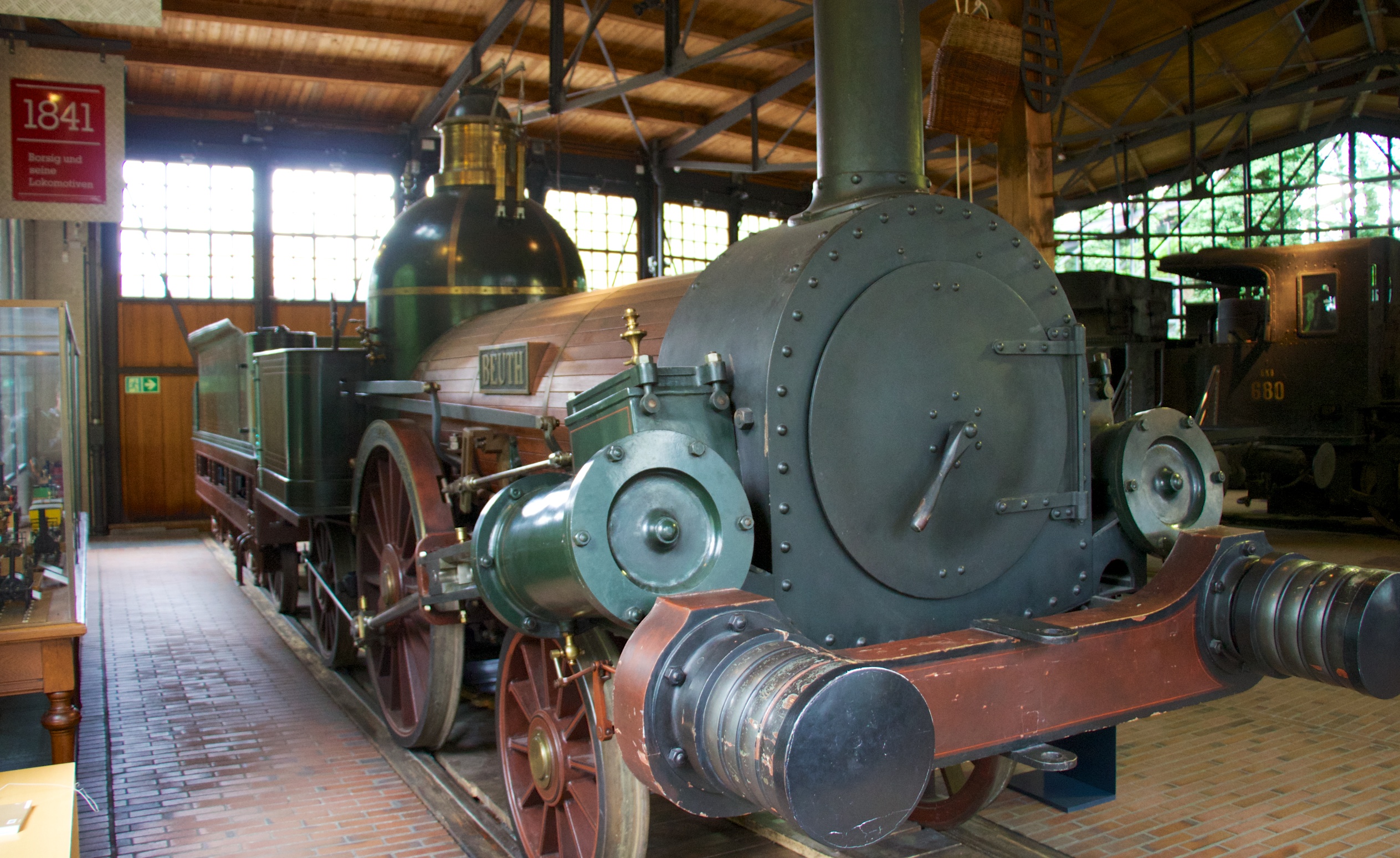
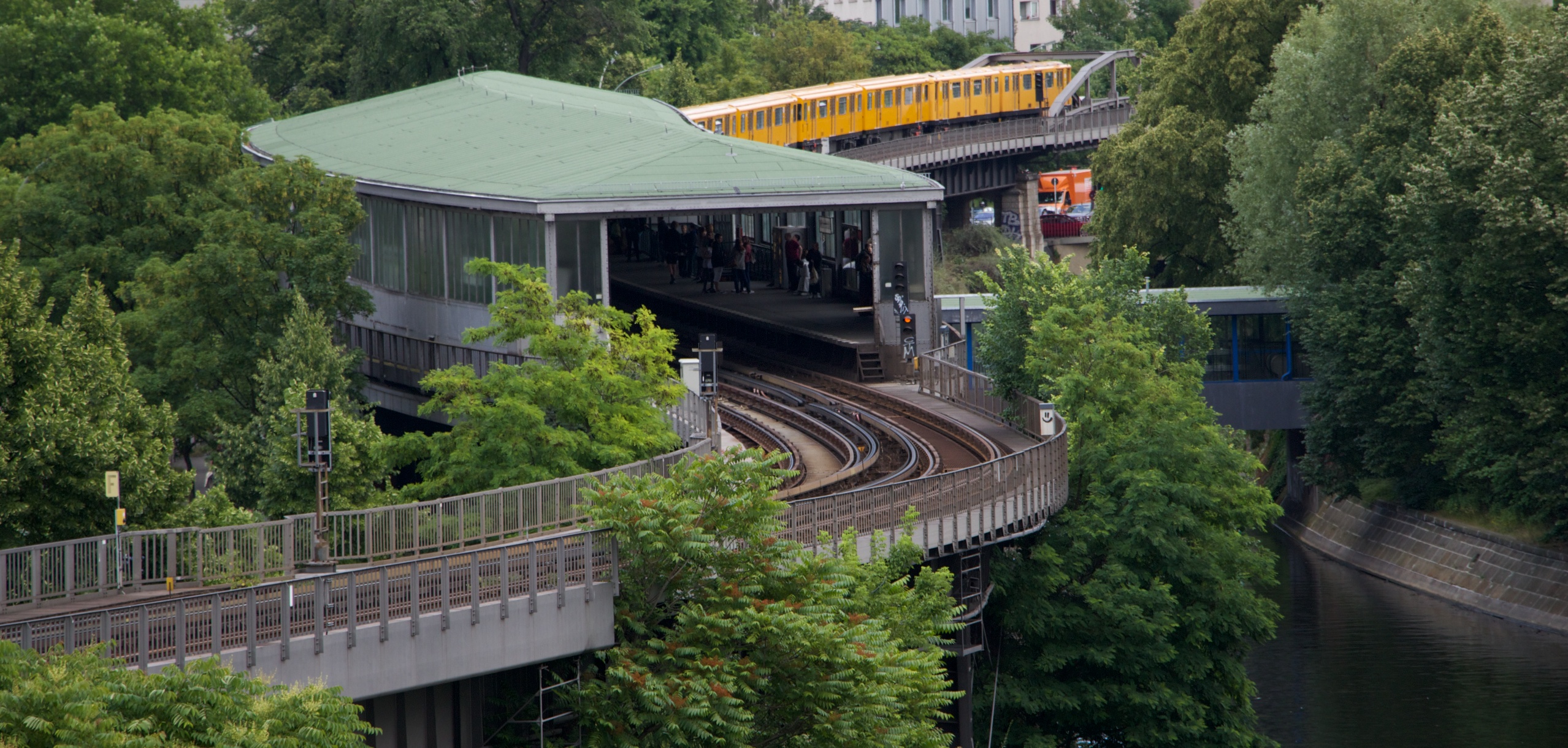
Travelling around Berlin today (on the S-Bahn from Alexanderplatz to Ostkreuz, and then on to Schönefeld airport for example), you see a lot of railway archeology – old shunting yards, signal boxes, engineering works – relics from a past where railways were even more important to the city’s life than they are today. In the museum, it suddenly dawned on me why Berlin, home to the revolutionary Borsig locomotive works, was such an early adopter of rail transport – not only was it a sprawling city in itself, it was (and is) so bloody far away from anywhere!
Berlin-built Borsig steam engine “Beuth” from 1842
Look at places like the UK and the Netherlands – both used railways to their economic advantage (although the Netherlands was notoriously late) – but both had proven alternatives in the way of well-developed canal and stage coach transport links, and distances were small, anyway.
Engine turning circle, originally part of Anhalter Bahnhof, reconstructed in situ in the 1970s for Technikmuseum
But in the case of Berlin, located in the midst of the East-Elbian steppe, there was no such alternative. Besides economic activity (freight) driving railway building, it must have been political and passenger demand that led to such a huge railway infrastructure radiating from the Prussian capital.
Möckernbrücke U-Bahn station, seen from the Technikmuseum
The legacy is here today: such was the rapid expansion of the railway system, and such was the continuous improvement technology and things like stations, that today there are lots of abandoned former railway stations turned into other interesting uses: parks (Nordbahnhof, Anhalter Bahnhof) or modern arts museum (Hamburger Bahnhof – built in the 1840s but already released from railway duty in 1884).
Prussian State Railways, ca. 1912. Image: wikipedia
And after the railways, history repeated itself in the early days of air travel: lots of aviation pioneers performed their flying experiments at Tegel and Tempelhof – again, not coincidentally, because the authorities were keen on entrepreneurs finding ways of breaking down the distances that separated Berlin from the outlying corners of the empire.
Junkers Ju 52/3m or “Tante Ju” (Auntie Ju) – developed for parallel military and civilian use in the 1930s. Mainstay of German passenger aviation.
I’m sure there’s nothing new in my ‘discovery’ of this – but for me at least it put Berlin’s five (at least) airports and heaps of current and abandoned railway stations into perspective. And it explains why Berlin has the material for such a great rail and air museum!
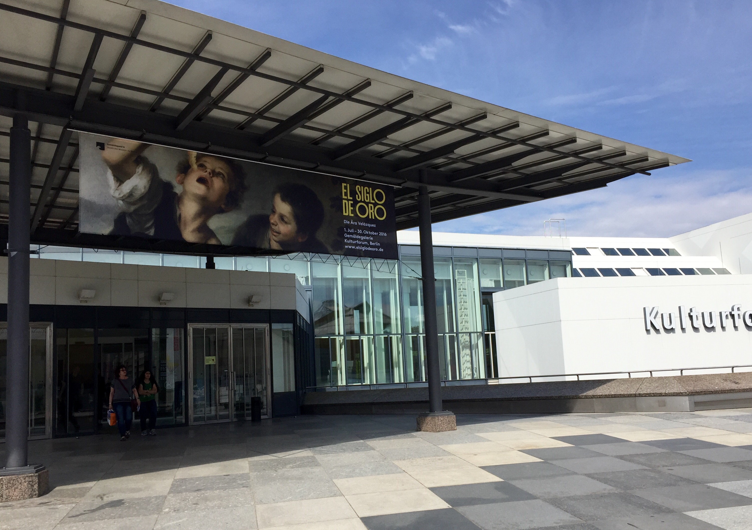 A temporary exhibition at one of my favourite Berlin museums, the Gemäldegalerie, introduced me to the Spanish Golden Age. The phrase “Siglo de Oro” didn’t ring any bells, even though as a Dutch history buff I know all about the Golden Age – the one in Holland, of course, not the Spanish one. It turns out that both countries’ Golden Ages coincided, both covering the late 1500s until the late 1600s.